By Ricky, on May 18th, 2015 Here Germany & Europe were divided until 08.00, 12th November 1989 © Ricky Yates
Observant readers of this blog may have noticed that my wife Sybille, has not had a mention in any of my recent posts. This is because on Maundy Thursday 2nd April, Sybille travelled by train from Prague to Görlitz, a town lying in the south-eastern corner of the former East Germany on the border with Poland. Then on Good Friday morning, she set out to walk from Görlitz, 470 km along Der Ökumenische Pilgerweg, to the small town of Vacha, which lies on the former Inner German Border.
Der Ökumenische Pilgerweg was established in 2002-3, almost solely by the efforts of one lady, Esther Zeiher. It follows the line of the ancient Via Regia passing through Leipzig, Erfurt and . . . → Read More: The Ökumenische Pilgerweg, Vacha and the Inner German Border
By Ricky, on April 12th, 2015 Hlavatice rock tower © Ricky Yates
Last Friday, during my post-Easter break, I explored the Hruboskalsko, another part of Ceský Ráj, a beautiful area of sandstone rocks and forests lying between 70-100 kilometres north east of Prague. Having parked my car in a designated parking area near the village of Pelešany, I made my way to join the red waymarked trail. This trail is designated the Zlatá Stezka or ‘Golden Trail’, so called because if you were to walk the whole of it, you would see all the best sights within Ceský Ráj.
After an initial climb, the trail brought me to this rock tower at Hlavatice. In the early years of the twentieth century, the local walking club erected a spiral . . . → Read More: Ceský Ráj revisted
By Ricky, on October 10th, 2014
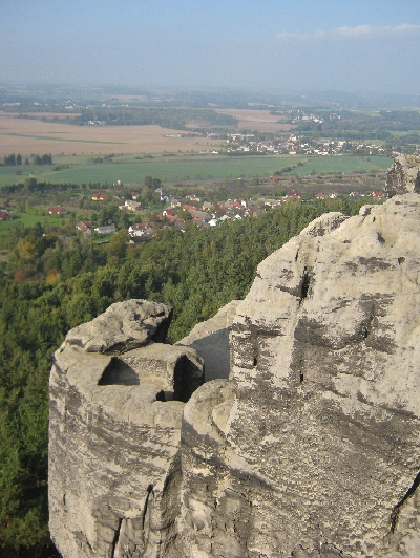
The view from Drábské svetnicky © Ricky Yates
Ceský Ráj, which literally translates into English as ‘Czech Paradise’ or ‘Bohemian Paradise’, is beautiful area of sandstone rocks and forests lying between 70-100 kilometres north east of Prague. Yesterday, on my first proper day-off for about a month, I took an 18 km walk through the western edge of Ceský Ráj, starting and finishing in the small town of Mnichovo Hradište.
After walking four kilometres from Mnichovo Hradište railway station, crossing the railway line, the Prague – Liberec motorway and then open fields, I reached the small village of Zásadka, which lies at the foot of the rocks. Here I enjoyed a traditional Czech lunch of Smažený sýr a hranolky, accompanied 0.5l of Svijany beer. Thus fortified, I set off further along the red waymarked route.
. . . → Read More: Ceský Ráj
By Ricky, on July 24th, 2014
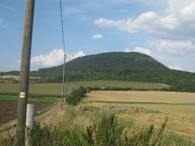
Hora Ríp as seen from Vražkov. Note the yellow waymark © Ricky Yates
Hora Ríp is a prominent hill, located about 48 km/30 miles north of Prague. It protrudes from the otherwise relatively flat Central Bohemian Plain, and is very visible and easily accessible from the D8, the Prague-Dresden motorway. Of course, there should be a hácek, a little hook, above the ‘R’ in ‘Ríp’, as there should be above the ‘c’ in ‘hácek‘. But as I have explained several times previously, the set-up of this blog cannot cope with many Czech diacritics and instead renders them as ‘?’ 🙁
Wearing my geographer hat, I can tell you that Hora R . . . → Read More: Hora Ríp
By Ricky, on August 3rd, 2013
Litice Castle © Ricky Yates
In advance of our recent holiday in the Orlické hory, I followed my usual practice and spent some time examining detailed maps of the area, looking for interesting places to walk and to visit. For those who don’t know, my first degree is in Geography and I’ve had a life-long love of maps 🙂
In the southern foothills of the Orlické hory, I spotted a wooded rocky outcrop, surrounded on three sides by the Divorká Orlice – ‘Wild Eagle River’, on top of which were the ruined remains of a castle – Hrad Litice / Litice Castle. It looked like a fascinating place so I put it on my ‘places to visit’ list for our holiday.
Hrad Litice / Litice Castle was a little too far to walk to from where were staying. So instead, we drove to . . . → Read More: Hrad Litice / Litice Castle
|
rickyyates.com is a participant in the Amazon Services LLC Associates Program, an affiliate advertising program designed to provide a means for sites to earn advertising fees by advertising and linking to Amazon.
|


Recent Comments