Royal Gardens, Stalin and the Metronome

Towers at the eastern end of the Prague Castle complex © Ricky Yates

Many of us here in Prague, are beginning to think that someone has kidnapped Spring and early Summer, the weather having been cold and wet for most of May. So Sybille and I decided to take full advantage of a rare, fine, dry and partly sunny evening earlier this week, and take a walk through some of Prague’s wonderful green spaces.

We took the tram to Pražský hrad / Prague Castle. But instead of crossing Prašný most, the bridge over Jelení príkop, and entering the Castle complex, we turned left into Královská zahrada, the Royal Gardens. As well as a wonderful collection of mature trees, there were several rhododendron bushes still in flower – shades of our visit to Pruhonice Park the previous week.

From the Royal Gardens, there are splendid views of Prague Castle. This photo shows the towers at the eastern end of the Castle complex. However, surrounded by trees and other greenery, you could be forgiven for thinking it to be scene from a small historic village in the Bohemian countryside, rather than a location in the centre of the Czech capital.


The view from Chotkovy sady © Ricky Yates

At the eastern end of the Royal Gardens is Chotkovy sady, from where this view down to the Malostranská tram stop with Charles Bridge beyond, was taken. From this point, a pedestrian bridge allowed us to cross the road and tram tracks below, and enter a far bigger green space, Letenské sady or Letná Park, as it is commonly called in English.

The Metronome in Letná Park © Ricky Yates


Letná Park occupies a plateau from which a steep slope goes down to the Vltava river. Walking along the path at the top of the slope, there are extensive views across the whole of that part of Prague that lies on the eastern side of the river. But sitting on top of a massive plinth and occupying the best viewpoint of all, is this slightly incongruous metronome. At least when we saw the metronome on our walk earlier this week, it was actually working. More often than not, it is stationary!

The metronome was erected in 1991, but the massive plinth on which it sits, has a far longer history going back to late 1949, only eighteen months after the coup that brought the Communist Party to power in February 1948. For on it once stood the largest group statue in Europe, measuring 15.5 metres in height and 22 metres in length.

Seeking to kowtow to the Soviet Union, the Central Committee of the Communist Party in Czechoslovakia decided to build a massive statue of Joseph Stalin. It took them five and a half years to construct it and, by the time it was unveiled on 1st May 1955, Stalin had already been dead for over two years.

The Prague Stalin Statue - Image via Wikimedia & in public domain
The Prague Stalin Statue – Image via Wikimedia & in the public domain


As you can see, the group statue was a classic example Communist era art on a gigantic scale. Stalin stands proudly overlooking the Vltava River, with archetypal workers and soldiers lining up behind him. The statue was informally known as ‘Fronta na maso‘, the ‘meat queue’, which was a daily part of life at that time. I am given to understand that there were also some far more descriptive titles – those that referred to what comrades standing behind Stalin, might be doing to his rear 🙂 As long as they are not too offensive, I’d love to know what these were, via comments on this post.

Less than a year after the statue was unveiled, Nikita Khrushchev denounced Stalin, both for his dictatorial rule and his cult of personality. Thus, this grand monument became an increasing embarrassment to the Czechoslovak Communist hierarchy. Therefore, in October 1962, the whole colossus was blown up with the help of 800 kg of explosives.

From the platform, immediately below the metronome, there is a view straight across Cechuv most, towards Staromestké námestí / Old Town Square. The street from the bridge to the square is called Parižská / Paris Street. Either side of Parižská, are some of the most exclusive and expensive shops in Prague. It is a view I suspect, that Stalin would not enjoy. So it is probably good that he no longer has to observe it 🙂

The view from Letná over Cechuv most © Ricky Yates
The view from Letná Park over Cechuv most © Ricky Yates


Berlin

The Brandenburger Tor/Brandenburg Gate © Ricky Yates
The Sony Centre, Potsdamer Platz © Ricky Yates

The Brandenburger Tor/Brandenburg Gate lies at the heart of the Historic Mitte/Historic Centre of Berlin. It was the backdrop to the events of 9th November 1989 that unfolded on television screens around the world and to which several people have made reference in their comments on my previous post about the Berlin Wall. As can be seen in my photograph above, it has now been fully restored to its former glory and it is hard to imagine the concrete panels of the Wall dividing east from west, that used to run directly in front of it.

A short distance south of the Brandenburg Gate is Potsdamer Platz, which until the Second World War, was the bustling heart of the city. Post 1945, it lay in ruins and was then divided by the Wall. Since reunification of the two German states in 1990, Potsdamer Platz has been completely redeveloped and now more resembles Manhattan than a European capital city. The photograph on the left is of the Sony Centre with its spectacular steel and glass roof. Below are pictured three skyscrapers which would not look out of place on the New York skyline.


Skyscrapers at Potsdamer Platz © Ricky Yates
Holocaust Memorial © Ricky Yates

In between the Brandenburger Tor/Brandenburg Gate and Potsdamer Platz is the Denkmal für die Erdemordeten Juden Europas, usually known simply as the Holocaust Memorial. Finally opened in May 2005, after many years of debate regarding its design and construction, the 2711 sarcophagi-like columns that rise up in silence across undulating ground, commemorate the Jewish victims of the Nazi-orchestrated genocide of World War Two.

The security controlled entrance  for the official opening of the memorial to Sinti & Roma victims of the Nazi regime © Ricky Yates

It is often forgotten or not even realised by many people today, that Jews were not the only victims of the Nazis. Just across the road from the Holocaust Memorial, in the edge of the Tiergarten, there is now a small memorial to Homosexuals who were also victims of the regime. And on our third day in Berlin, a new memorial, also located in the Tiergarten, commemorating Sinti and Roma victims, was officially opened by Chancellor Angela Merkel. The picture above is the nearest we could get to it due to understandable security restrictions being in place. But you can see it and read more about it, in this BBC News report.

The Reichstag © Ricky Yates

The reunification of Berlin has allowed the restoration of older buildings which had been in disrepair for many years. This is the Reichstag, home of the German parliament until seriously damaged by fire in mysterious circumstances in 1933. It suffered further damage during World War Two. With the decision to move the capital of a united Germany back to Berlin, the Reichstag underwent a complete reconstruction led by the British architect Norman Foster. After its completion in 1999, the building once again became the meeting place of the Bundestag, the lower house of the German parliament.

Berlin Hauptbahnhof © Ricky Yates

However, some buildings have been transformed and are now hardly recognisable from their pre-1945 appearance. A good is example is the main railway station – Berlin Hauptbahnhof.

Alexanderplatz © Ricky Yates

East Berlin was the capital of communist controlled East Germany. Inevitably here, you can still find plenty of examples of severe communist era architecture. This is Alexanderplatz, created during the 1960s and rightly described as ‘soulless and without trees’ by our guidebook. This despite post-unification attempts to temper the socialist look with a few small trees in the distance!

Communist era housing in East Berlin © Ricky Yates

Nearby, I photographed this classic example of communist era housing, still looking horribly drab.

The Olympiastadion/Olympic Stadium © Ricky Yates

Dating from a different era, this is the Olympiastadion/Olympic Stadium, built in 1936 as a showcase for Hitler’s Nazi Germany. In more recent years, it has been modernised, specifically for the Football World Cup Finals in 2006. It is also the home of Hertha Berlin, the city’s leading football club.

One thing Sybille was very keen to do whilst we were visiting the German capital, was to enjoy a Berlin culinary speciality – a Currywurst. Here she is, experiencing her first Currywurst for many years with appropriate liquid refreshment 🙂

Sybille enjoying her first Currywurst for many years © Ricky Yates

The Berlin Wall

A preserved section of the Berlin Wall © Ricky Yates

It is more than a little ironic that Berlin’s most popular tourist attraction, for the most part no longer exists! For 28 years, the Berlin Wall symbolised the Cold War and the division of Europe between the democratic and capitalist west, and the communist one-party states of the east, even if the communists did try to proclaim themselves as ‘democratic’ with the official name of the former East Germany being the Deutsche Demokratische Republik (DDR).

Construction of the wall began shortly after midnight on 13th August 1961 when thousands of East German soldiers and police rolled out massive lengths of barbed wire, cutting streets in two and preventing East Germans from travelling into West Berlin. Shortly afterwards, the barbed wire was replaced with a wall made of concrete slabs.

The Berlin Wall was a desperate measure by the East German communists, to stem the population flow from east to west which had seen 3.6 million Germans migrate between the foundation of the DDR in 1949, and the wall being erected in 1961. If the population drain had been allowed to continue, it would have soon brought the DDR to a point of economic and political collapse.

Although very euphemistically entitled the ‘Anti-Fascist Protection Barrier’ by the DDR authorities, it was rapidly reinforced on the East German side with the area behind the wall being cleared, trenches dug, barbed wire fences put in place, and a further inner wall, the Hinterlandmaurer, built on the other side to enclose the intervening death strip. Floodlighting at night and watch towers manned by trigger-happy guards were put in place to try to ensure no one escaped from the ‘communist paradise’ of the DDR 😉

Crosses commemorating individuals who lost their lives trying to cross the Berlin Wall © Ricky Yates

Many people did still try to escape, some successfully but many were killed or died in the process. This is one of several memorials commemorating some of the victims.

Old East German watchtower © Ricky Yates

The demise of the Berlin Wall came almost as quickly as its creation twenty-eight years earlier. In the Autumn of 1989, the DDR once more started losing its people in large numbers as Hungary opened its border with Austria. Demonstrations and demands for reform grew quickly within the DDR and on 9th November 1989, the communist authorities bowed to the inevitable and announced on DDR television that all restrictions on travel to the west would be lifted immediately.

Crowds gathered at various checkpoints along the Wall that evening, eventually overwhelming the border guards by their sheer weight of numbers. People started to dance on top of the wall whilst others began to attack parts of it with sledgehammers, chipping away pieces of concrete as souvenirs. Over the following months, large sections were demolished and removed.

Today, other than a few preserved sections such as that in the photograph at the beginning of this post, there is very little left of of the Berlin Wall and its associated fortifications. This former East German watchtower pictured here, sits slightly incongruously in a side street near Potsdammer Platz. In the meantime, the two city halves have visually merged making it difficult to discern whether one is in the East or the West.

Other short sections of the Wall have been preserved, including the remains of artwork or graffiti, (depending on your point of view 🙂 ), with which West Berliners decorated their side of the wall, with explanatory boards placed in between, explaining the history of the Berliner Maurer. The example in the photograph below is located on the line of where the Wall once stood, also not far from Potsdammer Platz.

Preserved sections of the Berlin Wall with explanatory boards © Ricky Yates
The double row of cobblestones marking the former course of the Berlin Wall © Ricky Yates


In recognition that visiting tourists will want to know where the Berlin Wall once stood, a double row of cobblestones has been placed showing the line of its former course.

Since the collapse of the Berlin Wall and subsequent German reunification, the derelict area between the original Wall and the Hinterlandmaurer, has been prime land for redevelopment. Some older, often war-damaged buildings located in or adjacent to the ‘security strip’ have been renovated and restored, whilst elsewhere, completely new construction has taken place.

The picture below shows an area of the ‘security strip’ just south of the Brandenburg Gate. On the right, in the foreground of the photograph, is one corner of the Holocaust Memorial about which more in text and pictures in a future post. Immediately beyond are a series of newly-constructed cafés and restaurants, where even in late October when we visited, it was still possible to sit at outside tables.

However, the apartment blocks beyond the cafés and restaurants are located in the former East Berlin and were built by the communist regime post-1961. They are colloquially known as Luxusplatte – luxury flats, but still built in the typical communist manner using concrete panels. Only very faithful Communist Party members were allowed to live in them, that is only those who could be trusted not to try to escape to the west, because they lived so close to the Wall 😉


Part of the redeveloped former ‘security strip’ with Luxusplatte beyond © Ricky Yates

One of the buildings that lay within the former ‘security strip’ was that which housed the British Embassy until the breaking off of diplomatic relations at the outbreak of the Second World War in 1939. The building itself was subsequently badly damaged by allied bombing. When the newly reunited Germany once again made Berlin its capital city in 1999, the British government decided to rebuild its embassy on the same site with the new building pictured below, being officially opened by Her Majesty Queen Elizabeth II on 18th July 2000.

The British Embassy in Berlin © Ricky Yates

Liberation Day – 8th May 2012

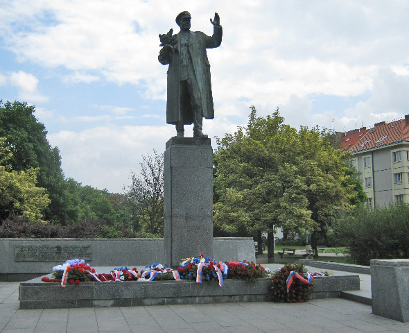
Statue of Soviet Marshall Ivan Konev with floral tributes © Ricky Yates
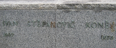
Inscription alongside the statue © Ricky Yates

Today is a public holiday here in the Czech Republic, as it is in several other European countries. The public holiday marks the ending of World War Two, sixty-seven years ago, on 8th May 1945.

I took the photograph on the left today. It is of a statue that stands in Námestí Interbrigády, a large square on one side of Jugoslávských partyzánu, the main thoroughfare leading from our nearest Metro station at Dejvická, to Podbaba where we live. And the person it portrays is Marshall Ivan Stepanovich Konev of the Soviet Red Army, who led the troops that liberated Prague from Nazi occupation, finally entering the city early on 9th May 1945, just a few hours after the unconditional surrender of all Nazi troops across Europe, had come into force.

As I wrote in an earlier post on this same topic two years ago, this statue is a rare sight today, anywhere in the Czech Republic or Slovakia, as it features a leading figure of the Soviet Army which, during nearly forty-two years of communism, was regarded as an army of occupation by the people of Czechoslovakia. Nearly all public monuments featuring or seeking to celebrate, ‘Soviet friendship and brotherhood’ have, since the Velvet Revolution of 1989, been quietly removed. But, because it commemorates an event that took place before the communist coup in 1948, it remains standing.

As you can see, a large number of floral tributes have been placed at the foot of the statue in recent days. Some are official, such as the ones from the Czech Military and from the Defence Office of the Czech President. Others are simple bunches of flowers, left by private individuals. Although there is a considerable dislike of Russia and Russians amongst the Czech people today, (see some of the comments on my previous post), there is a recognition that it was the Soviet Army that was responsible for liberating Prague and two thirds of what is now the Czech Republic, early in May 1945.

Floral tribute with Cyrillic writing © Ricky Yates

However, I was intrigued by one large floral tribute pictured here, whose ribbons have an inscription written in a language using the Cyrillic alphabet, presumably Russian. If anyone can tell me what it says or which organisation might be responsible for it, I would love to know.

Inscription behind the statue which refers to the Czechoslovak Socialist Republic © Ricky Yates

And I was also intrigued by this inscription on the low wall behind the statue, which refers to the country as the Czechoslovak Socialist Republic, the name used only during the years of communist rule. Whereas elsewhere in the Czech Republic, specific communist logos and references have been removed from war memorials such as in Tábor, here communist nomenclature remains.

Whilst the liberation of the country from Nazi occupation is still marked each year here in the Czech Republic, what has changed since the Velvet Revolution, is the attitude of Czech people towards Germany and the German people. Most Czechs are now freely able to distinguish between Nazi Fascist ideology as exemplified by Hitler’s Third Reich, and present-day democratic Germany, still very much aware of it’s relatively recent past history.

Therefore these days, Germany is the Czech Republic’s biggest trading partner. Germans also travel here in considerable numbers to enjoy the delights of what this country has to offer and in doing so, make a major contribution to the Czech Republic’s tourist income.

On the other hand, although the part played by Russia and the Soviet Red Army to liberate the country from Nazi occupation is still acknowledged each year, those who liberated, in turn became an army of occupation. And although all Russian troops had left Czech soil by June 1991, there remains a strong feeling that Russia still wants to control its former republics and satellite states using its economic power, particularly with regard to the supply and distribution of natural gas.

Bucharest

View along a side street in Central Bucharest © Ricky Yates

I spent a further 24 hours in Bucharest following our Archdeaconry Synod meeting, not least because flying back to Prague on Monday afternoon was far cheaper than flying back on Sunday evening! I used the time exploring the city centre by bus and on foot, and I hope that these photographs will give readers of my blog, some impression of what Bucharest is like.

Looking at the photograph on the left, it would be very easy to think that it was taken in Paris or another French city, rather than in Bucharest. And many of the most attractive buildings dating from the latter half of the nineteenth century and the early part of the twentieth century do display a French architectural style. This is because of the strong French-Romanian links during this time period with many French architects working in Romania and Romanian architects training at French architectural schools.

Below are three more examples of attractive buildings in the French architectural style all located within Central Bucharest. As can be seen, they have each been renovated in recent times after many years of neglect during the communist era.

Romanian Atheneum, Bucharest © Ricky Yates
Central University Library, Bucharest © Ricky Yates
Military Officers Club, Bucharest © Ricky Yates

The French influence even extends to a small version of Paris’ Arc de Triomphe. The Romanian version pictured below, celebrates the re-unification of the country in 1918 at the end of the First World War. Alongside the photograph of Bucharest’s ‘Triumphal Arch’, is a view along another city centre side street which once more illustrates the influence of French nineteenth century architecture. However, the photograph also shows more recent Czech influence with the Staropramen Beer logo featuring on the sun awning and sign of the street-side bar-restaurant!

Triumphal Arch, Bucharest © Ricky Yates

Side street in Central Bucharest with a Staropramen Bar © Ricky Yates

However, as in Prague and the other capital cities of the former Warsaw Pact countries of Central and Eastern Europe, you cannot avoid seeing the impact of over forty years of Communist rule. Below is a photograph of Casa Presei Libere/Press House, a wonderful example of Stalinist-Baroque architecture, completed in 1956. During the period of Communist rule, all print media emanated from this building, hence it was always known informally as the ‘House of Lies’.

Casa Presei Libere/Press House, Bucharest © Ricky Yates

This building in the photograph below, is a large Communist era Conference Centre, built to facilitate the holding of Communist Party Congresses.

Communist era Conference Centre, Bucharest © Ricky Yates

The Communist Party leader of Romania from March 1965 until he was overthrown in the revolution of December 1989, was Nicolae Ceausescu. Following a visit to North Korea in the early 1970s, Ceausescu embarked upon an extraordinary scheme to refashion an entire section of Bucharest according to his own megalomaniacal vision. As part of the scheme, about one sixth of the capital’s buildings were demolished, many of considerable historicity including thirteen Churches.

The pinnacle of Ceausescu’s scheme was the construction of the second-largest building in the world (after the Pentagon in Washington), now known as the Palace of Parliament. Started in 1984 but never completed, it has 12 storeys and 3100 rooms and covers an area of 330,000 square metres.

Palace of Parliament, Bucharest © Ricky Yates

From the Palace of Parliament, a four kilometre-long boulevard was created, deliberately designed to be a few metres wider than the ChampsÉlysées in Paris. All this was done to satisfy the egotistical whims of Ceausescu and his wife Elena, around whom was built a major personality cult.

The boulevard leading from the Palace of Parliament, Bucharest © Ricky Yates

Ceausescu was overthrown in the revolution of December 1989. Still under the delusion that he was popular with the Romanian people despite a revolt in the western city of Timisoara, Ceausescu tried to address the crowds from the balcony of the headquarters building of the Central Committee of the Communist Party on 21st December 1989. A few minutes into his speech, instead of cheers and applause, the crowd began to boo and heckle him. Unable to control the crowd, he withdrew from the balcony into the building.

The former headquarters of the Central Committee of the Communist Party in Bucharest with the balcony from where Nicolae Ceausescu made his last speech © Ricky Yates

The crowd outside was broken up by military force using live ammunition which resulted in the death of many of the protesters. The following day, Ceausescu tried again to address the crowds who had once more gathered outside the building. This time, they responded by throwing rocks and missiles and eventually broke into the building, forcing him, together with his wife Elena, to flee by helicopter from the roof. A couple of days later, the couple were arrested, put on trial for two hours before an Extraordinary Military Tribunal, given death sentences and then shot by a three man firing squad.

Memorial to those killed in the December 1989 revolution outside the former Communist Party HQ © Ricky Yates

Fortunately, despite all that Ceausescu and his regime did to the city of Bucharest, many Orthodox Church buildings have survived. Here are two examples that I was briefly able to visit and photograph.

Cretulescu Church, Bucharest © Ricky Yates
Romanian Orthodox Church, Bucharest © Ricky Yates

And finally, here is a third example which, as you can see, is currently undergoing restoration work. This Church belongs to a Romanian Orthodox Convent and where several of us had the privilege of listening to a small group of young nuns sing Vespers on the evening of Sunday 25th September.

Romanian Orthodox Convent Church under restoration, Bucharest © Ricky Yates