Neratov

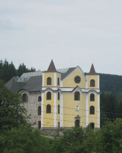
Neratov Church © Ricky Yates

Neratov is a small village located on the eastern side of the Orlické hory, in the valley of the Divorká Orlice – ‘Wild Eagle River’, which forms the border between the Czech Republic and Poland. Between 1723-33, a large baroque Church was built here, to house a statue of the Virgin Mary that had been previously donated by the parish priest of Rokynice v Orlických horách, situated on the other side of mountain range. Thus Neratov became a place of pilgrimage and Marian devotion.

The Church, built on a rocky promontory overlooking the village, is most unusual in one particular aspect. It has a north-south, rather than the traditional east-west, axis. The only other Church I know built in this manner, is the new Coventry Cathedral, which is at right-angles to the old ruined Cathedral.

On 10th May 1945, two days after the Second World War was supposed to have come to an end, the Church was hit by a Soviet Red Army anti-tank rocket and was gutted by fire. The roof and interior fittings were completely destroyed, just leaving the exterior walls standing. Then in 1957, some supporting arches collapsed. In 1973, an order was issued for the demolition of the ruined remains and the only reason the building survived, was because the local communist authorities, lacked the finances to put the demolition order into effect 🙂
Neratov 2
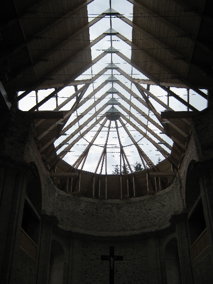
The new glass roof of Neratov Church © Ricky Yates

Following the Velvet Revolution of 1989, moves began to be made to preserve and then restore the Church. In 1992, it was declared the equivalent of a British ‘listed building’. Then in 2006-2007, it was completely re-roofed. This has been done in the most imaginative way with timber framing supporting clear glass, allowing a remarkable amount of light into the interior of the Church. The money to carry out the restoration came from a variety of sources including Germany. This website in German, is maintained by supporters of the project. It uses the name Bärnwald, which is how the village is known in German.
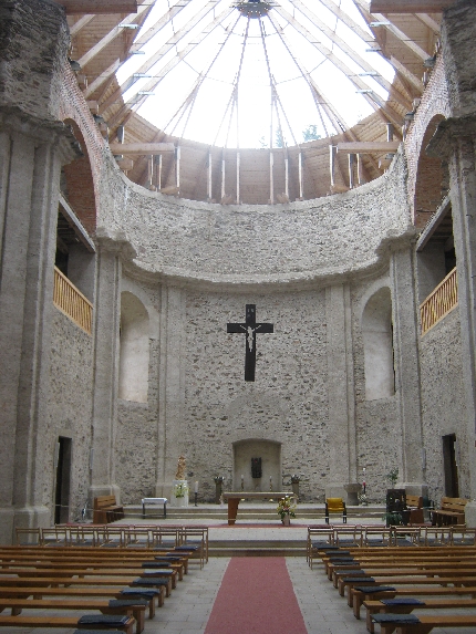
The interior of Neratov Church © Ricky Yates

Both Sybille and I very much enjoyed our ‘pilgrimage’ to Neratov – we did walk around 15 km from Rícky v Orlických horách to get there! Unlike so many Czech Churches, Neratov Church is kept open during daylight hours. Also, because of the 1945 fire, unlike so many baroque Churches in Prague and elsewhere in the Czech Republic, the interior walls are plain with just a large crucifix on the north wall behind the altar, and a small new statue of the Virgin Mary in the north-west corner. It is very hard to find the right words to articulate the real sense of peace and holiness that I felt whilst being there.

The village itself has also been brought to life by the Neratov Association, which has provided sheltered housing and employment, for people with light to medium mental handicaps. As explained in a small colour leaflet that I picked up in the Church, ‘the aim is to help these people to live a free, independent, and responsible life with the support of a team of assistants in a friendly family-like environment’.
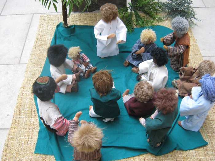
Neratov 4
Jesus asking questions of his twelve disciples © Ricky Yates

I suspect that these figures, sitting in front of the lectern in the sanctuary of the Church, are the work of some of those in the care of the Neratov Association. The text in Czech, of Luke 9. 18-20, was on display alongside them. Jesus is asking first, ‘Who do the crowds say I am?’ And then more pointedly, ‘Who do you say I am?’

Our visit to Neratov was the first of several days of fascinating discoveries, as we explored the Orlické hory. I hope to write and post more about our experiences in the coming days.

Berlin

The Brandenburger Tor/Brandenburg Gate © Ricky Yates
The Sony Centre, Potsdamer Platz © Ricky Yates

The Brandenburger Tor/Brandenburg Gate lies at the heart of the Historic Mitte/Historic Centre of Berlin. It was the backdrop to the events of 9th November 1989 that unfolded on television screens around the world and to which several people have made reference in their comments on my previous post about the Berlin Wall. As can be seen in my photograph above, it has now been fully restored to its former glory and it is hard to imagine the concrete panels of the Wall dividing east from west, that used to run directly in front of it.

A short distance south of the Brandenburg Gate is Potsdamer Platz, which until the Second World War, was the bustling heart of the city. Post 1945, it lay in ruins and was then divided by the Wall. Since reunification of the two German states in 1990, Potsdamer Platz has been completely redeveloped and now more resembles Manhattan than a European capital city. The photograph on the left is of the Sony Centre with its spectacular steel and glass roof. Below are pictured three skyscrapers which would not look out of place on the New York skyline.


Skyscrapers at Potsdamer Platz © Ricky Yates
Holocaust Memorial © Ricky Yates

In between the Brandenburger Tor/Brandenburg Gate and Potsdamer Platz is the Denkmal für die Erdemordeten Juden Europas, usually known simply as the Holocaust Memorial. Finally opened in May 2005, after many years of debate regarding its design and construction, the 2711 sarcophagi-like columns that rise up in silence across undulating ground, commemorate the Jewish victims of the Nazi-orchestrated genocide of World War Two.

The security controlled entrance  for the official opening of the memorial to Sinti & Roma victims of the Nazi regime © Ricky Yates

It is often forgotten or not even realised by many people today, that Jews were not the only victims of the Nazis. Just across the road from the Holocaust Memorial, in the edge of the Tiergarten, there is now a small memorial to Homosexuals who were also victims of the regime. And on our third day in Berlin, a new memorial, also located in the Tiergarten, commemorating Sinti and Roma victims, was officially opened by Chancellor Angela Merkel. The picture above is the nearest we could get to it due to understandable security restrictions being in place. But you can see it and read more about it, in this BBC News report.

The Reichstag © Ricky Yates

The reunification of Berlin has allowed the restoration of older buildings which had been in disrepair for many years. This is the Reichstag, home of the German parliament until seriously damaged by fire in mysterious circumstances in 1933. It suffered further damage during World War Two. With the decision to move the capital of a united Germany back to Berlin, the Reichstag underwent a complete reconstruction led by the British architect Norman Foster. After its completion in 1999, the building once again became the meeting place of the Bundestag, the lower house of the German parliament.

Berlin Hauptbahnhof © Ricky Yates

However, some buildings have been transformed and are now hardly recognisable from their pre-1945 appearance. A good is example is the main railway station – Berlin Hauptbahnhof.

Alexanderplatz © Ricky Yates

East Berlin was the capital of communist controlled East Germany. Inevitably here, you can still find plenty of examples of severe communist era architecture. This is Alexanderplatz, created during the 1960s and rightly described as ‘soulless and without trees’ by our guidebook. This despite post-unification attempts to temper the socialist look with a few small trees in the distance!

Communist era housing in East Berlin © Ricky Yates

Nearby, I photographed this classic example of communist era housing, still looking horribly drab.

The Olympiastadion/Olympic Stadium © Ricky Yates

Dating from a different era, this is the Olympiastadion/Olympic Stadium, built in 1936 as a showcase for Hitler’s Nazi Germany. In more recent years, it has been modernised, specifically for the Football World Cup Finals in 2006. It is also the home of Hertha Berlin, the city’s leading football club.

One thing Sybille was very keen to do whilst we were visiting the German capital, was to enjoy a Berlin culinary speciality – a Currywurst. Here she is, experiencing her first Currywurst for many years with appropriate liquid refreshment 🙂

Sybille enjoying her first Currywurst for many years © Ricky Yates

The Berlin Wall

A preserved section of the Berlin Wall © Ricky Yates

It is more than a little ironic that Berlin’s most popular tourist attraction, for the most part no longer exists! For 28 years, the Berlin Wall symbolised the Cold War and the division of Europe between the democratic and capitalist west, and the communist one-party states of the east, even if the communists did try to proclaim themselves as ‘democratic’ with the official name of the former East Germany being the Deutsche Demokratische Republik (DDR).

Construction of the wall began shortly after midnight on 13th August 1961 when thousands of East German soldiers and police rolled out massive lengths of barbed wire, cutting streets in two and preventing East Germans from travelling into West Berlin. Shortly afterwards, the barbed wire was replaced with a wall made of concrete slabs.

The Berlin Wall was a desperate measure by the East German communists, to stem the population flow from east to west which had seen 3.6 million Germans migrate between the foundation of the DDR in 1949, and the wall being erected in 1961. If the population drain had been allowed to continue, it would have soon brought the DDR to a point of economic and political collapse.

Although very euphemistically entitled the ‘Anti-Fascist Protection Barrier’ by the DDR authorities, it was rapidly reinforced on the East German side with the area behind the wall being cleared, trenches dug, barbed wire fences put in place, and a further inner wall, the Hinterlandmaurer, built on the other side to enclose the intervening death strip. Floodlighting at night and watch towers manned by trigger-happy guards were put in place to try to ensure no one escaped from the ‘communist paradise’ of the DDR 😉

Crosses commemorating individuals who lost their lives trying to cross the Berlin Wall © Ricky Yates

Many people did still try to escape, some successfully but many were killed or died in the process. This is one of several memorials commemorating some of the victims.

Old East German watchtower © Ricky Yates

The demise of the Berlin Wall came almost as quickly as its creation twenty-eight years earlier. In the Autumn of 1989, the DDR once more started losing its people in large numbers as Hungary opened its border with Austria. Demonstrations and demands for reform grew quickly within the DDR and on 9th November 1989, the communist authorities bowed to the inevitable and announced on DDR television that all restrictions on travel to the west would be lifted immediately.

Crowds gathered at various checkpoints along the Wall that evening, eventually overwhelming the border guards by their sheer weight of numbers. People started to dance on top of the wall whilst others began to attack parts of it with sledgehammers, chipping away pieces of concrete as souvenirs. Over the following months, large sections were demolished and removed.

Today, other than a few preserved sections such as that in the photograph at the beginning of this post, there is very little left of of the Berlin Wall and its associated fortifications. This former East German watchtower pictured here, sits slightly incongruously in a side street near Potsdammer Platz. In the meantime, the two city halves have visually merged making it difficult to discern whether one is in the East or the West.

Other short sections of the Wall have been preserved, including the remains of artwork or graffiti, (depending on your point of view 🙂 ), with which West Berliners decorated their side of the wall, with explanatory boards placed in between, explaining the history of the Berliner Maurer. The example in the photograph below is located on the line of where the Wall once stood, also not far from Potsdammer Platz.

Preserved sections of the Berlin Wall with explanatory boards © Ricky Yates
The double row of cobblestones marking the former course of the Berlin Wall © Ricky Yates


In recognition that visiting tourists will want to know where the Berlin Wall once stood, a double row of cobblestones has been placed showing the line of its former course.

Since the collapse of the Berlin Wall and subsequent German reunification, the derelict area between the original Wall and the Hinterlandmaurer, has been prime land for redevelopment. Some older, often war-damaged buildings located in or adjacent to the ‘security strip’ have been renovated and restored, whilst elsewhere, completely new construction has taken place.

The picture below shows an area of the ‘security strip’ just south of the Brandenburg Gate. On the right, in the foreground of the photograph, is one corner of the Holocaust Memorial about which more in text and pictures in a future post. Immediately beyond are a series of newly-constructed cafés and restaurants, where even in late October when we visited, it was still possible to sit at outside tables.

However, the apartment blocks beyond the cafés and restaurants are located in the former East Berlin and were built by the communist regime post-1961. They are colloquially known as Luxusplatte – luxury flats, but still built in the typical communist manner using concrete panels. Only very faithful Communist Party members were allowed to live in them, that is only those who could be trusted not to try to escape to the west, because they lived so close to the Wall 😉


Part of the redeveloped former ‘security strip’ with Luxusplatte beyond © Ricky Yates

One of the buildings that lay within the former ‘security strip’ was that which housed the British Embassy until the breaking off of diplomatic relations at the outbreak of the Second World War in 1939. The building itself was subsequently badly damaged by allied bombing. When the newly reunited Germany once again made Berlin its capital city in 1999, the British government decided to rebuild its embassy on the same site with the new building pictured below, being officially opened by Her Majesty Queen Elizabeth II on 18th July 2000.

The British Embassy in Berlin © Ricky Yates

Liberec

Liberec Town Hall © Ricky Yates

The city of Liberec is situated 110 km north-east of Prague, quite close to the border of the Czech Republic with both Germany and Poland. Known in German as Reichenberg, it lies within the former Sudetenland and had a majority German-speaking population until the vast majority were expelled in 1945-6, at the end of the Second World War.

We paid our first visit to Liberec on my day-off four weeks ago, Monday 8th October. The chief reason for our trip was to visit Liberec Zoo, which is home to a pair of rare White Bengal Tigers, who earlier this year, successfully produced three tiger cubs.

Liberec Zoo is located in a leafy suburb east of the city centre. It has the distinction of being the oldest zoo in the Czech Republic, having been founded in 1919, well before Prague Zoo which was founded in 1931. On the day we visited, there were remarkably few other visitors, and nearly all of them seemed to be German 🙂 It was also noticeable that once any member of the local population realised we were not Czech, we got spoken back to in German!

Whilst we did get to see the white tiger cubs, it was near impossible to get a decent photograph of them. But Sybille did get this photograph below of their mother.

White Bengal Tiger © Sybille Yates
Sign in four languages © Ricky Yates

Just outside the building housing the White Tigers and their cubs was this sign. Friends on Facebook will have seen my photograph already as I posted it there the same day as I took it. As I entitled it then;

In Deutschland wird englisch gesprochen, aber in Großbritannien sprechen wir deutsch – In Germany we speak English, but in Great Britain we speak German.”

And yes – both the English and German texts are in need of considerable improvement. The English text seems to imply that the White Tigers are being bred in the collection box 🙂 It reminds me of a line from a letter written by a lady to her employer explaining her absence from work – “This is to advise you that I have given birth to twins in the enclosed envelope” 😉

Meerkats in Liberec Zoo © Ricky Yates


There were many other interesting animals and birds to see elsewhere in the zoo including these delightful meerkats.

Later in the afternoon, we drove from the zoo to the centre of the city, parked the car, and set out to explore on foot. In the latter half of the nineteenth century, Liberec was a very prosperous city, home to a thriving textile industry resulting in it being known as the ‘Manchester of Bohemia’. Some of the city’s most significant buildings date from that time including the Town Hall featured in the photograph at the beginning of this post and the F.X. Šalda Theatre pictured below.

F.X. Šalda Theatre, Liberec © Ricky Yates

Both the Town Hall and the Theatre are situated on the main city square, Námestí Dr. E. Beneše. Here are some more attractive buildings on another side of the same square.

Attractive buildings on one side of Námestí Dr. E. Beneše, Liberec © Ricky Yates
Valdštýnské domky (Czech) or Waldsteinhäuser (German) dating from 1678-81 © Ricky Yates

However, the origins of Liberec can be traced back to at least the fourteenth century. These half-timbered houses are some of the earliest remaining buildings still standing within the city and date from 1678-81. They are known as Valdštýnské domky (Czech) or Waldsteinhäuser (German).

Memorial to the victims of the Soviet invasion of August 1968 © Ricky Yates


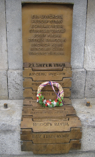
Adjacent to the Town Hall is this reminder of more recent history. It is a memorial to those Liberec citizens who died trying to resist the Soviet invasion of August 1968. Most were killed being run over by tanks, hence this memorial, presumably erected since the Velvet Revolution of December 1989, is in the form of caterpillar tracks that are found on tanks. The reversed imprint of the victims names on the lower half of the memorial, bears an uncanny resemblance to writing using the Cyrillic alphabet, the alphabet with which Russian is written.

An even more recent edition to the landscape of Námestí Dr. E. Beneše are these three cats. I had to wait sometime to get this photograph because so many children were busy either  jumping on or sitting on them!

Three cats in Liberec © Ricky Yates

A weekend in Brno

Sv Jakuba / Church of St James, Brno © Ricky Yates

As I explained in my previous post, we spent the last weekend of our recent holiday, in Brno, the second-largest city in the Czech Republic. Brno is just over 200 kilometres south-east of Prague and is situated at the confluence of the Svratka and Svitava rivers. With a population of about 400,000, the city is about one third of the size of the Czech capital.

Within the historic centre of Brno, there are a whole variety of different Churches. The one pictured on the left here, is dedicated to Sv Jakuba / St. James and is a fine example of baroque architecture. According to my ‘Brno City Guide’, the top of the spire is 92 metres high.

We were pleased to be able to walk around the interior of the Church and observe the very high pillars which in turn, support a fine vaulted roof. Being a Church dedicated to St. James, we were not surprised to find a photographic display of a group of parishioners who had made the pilgrimage to Santiago de Compostela a few years previously. But they clearly had started walking to Santiago at some point in Spain, unlike their mediaeval forebears, whose pilgrimage would, no doubt, have begun at the west door of this Church!

Cervený kostel /Red Church, Brno © Ricky Yates

The Church pictured on the right is known as Cervený kostel or in English as ‘The Red Church’. It is one of several similar red brick Churches that can be found in various parts of the Czech Republic, all dating from the second half of the nineteenth century. They were built following a ‘Toleration of Protestants’ act of the Austro-Hungarian Empire in the 1850s, which for the first time allowed protestant groups to build and own church buildings which actually looked like Churches with towers or spires and bells.

When first built, this Church was used for worship by German-speaking Lutherans. There was a large German-speaking population in Brünn, (as German-speakers still call Brno), until the expulsion of the Sudetendeutsche in 1945 following the end of the Second World War. It now belongs to the Evangelical Church of Czech Brethren, the largest Protestant denomination in the Czech Republic who came into being in December 1918, when the Czech-speaking Lutheran Church amalgamated with the Czech-speaking Presbyterian/Reformed Church.

Below is pictured the Roman Catholic Cathedral Church of St. Peter and St. Paul. Although situated on the site of previous Churches dating from the thirteenth and fourteenth centuries, the building obtained its current Neo-Gothic appearance when it was reconstructed in the early years of the twentieth century.

The Cathedral Church of St. Peter & St. Paul, Brno © Ricky Yates
Entrance to Špilberk Castle, Brno © Ricky Yates


Immediately west of the historic centre of Brno, is a rocky outcrop on which stands Hrad Špilberk / Špilberk Castle. Founded in the second half of the thirteenth century, the castle has been altered, extended and rebuilt many times since. It also has a chequered history, (please excuse the pun), which in many ways, reflects the experience of the Czech people over the centuries. One of its many claims to fame is resisting a siege lasting four months, by Swedish troops in 1645, thus changing the eventual outcome of the Thirty Years War.

The fortifications are impressive which I hope will be well illustrated by the photograph below. At various times Špilberk Castle has been both a prison and a military barracks. Since 1960, it has been part of Brno City Museum and we spent most of our Saturday afternoon in Brno, visiting two different exhibitions within the castle – one explaining the numerous centuries of central European history – the other, a wonderful collection of art work from the late nineteenth century through to the beginning of the Second World War.


The fortifications of Špilberk Castle © Ricky Yates

Below are two photographs that I took when exploring the castle complex. One shows the depth of the moat that surrounds the central part of the castle. The other shows part of the casements, a series of rooms constructed within the castle walls which have been used over time as both prison cells and for the storage of military armaments.

Moat of Špilberk Castle, Brno © Ricky Yates

Casement within Špilberk Castle, Brno © Ricky Yates
Decorated building in Brno © Ricky Yates

Just as in Prague, it is possible to walk the streets of the historic centre of Brno, and see a whole variety of different styles of architecture and artistic decoration on the exterior of buildings. This one photograph doesn’t do justice to the wealth and variety that there is to be seen.


Historic tram in Brno © Ricky Yates

Likewise as in Prague, Brno has an excellent public transport network including many trams. At weekends, this historic tram runs along a central circuit, a reminder of how public transport used to be many decades ago.

Over the weekend, we enjoyed the company and hospitality of our friends Lynsey and Johnny who walked around with us all day on Saturday 28th July. Late in the afternoon, they took us for some well-earned drinks at one of their favourite Brno cafés.

Lynsey & Johnny relaxing in a Brno café © Ricky Yates

As you can see, Johnny’s friend Pfeffer, who travels around with him in his shoulder bag, took a fancy to my beer 🙂

Pfeffer enjoying my beer! © Ricky Yates