Ceský les

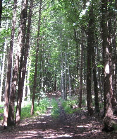
Footpath through Ceský les © Ricky Yates

We spent the second week of our recent holiday, Tuesday 19th – Sunday 24th July, staying as we had previously done in October 2010, in a delightfully restored house dating from the first decade of the twentieth century that belongs to Jack, an Irish member of the St. Clement’s congregation. It is situated in the somewhat unusually named village of Babylon, which lies between the town of Domažlice and the German border, in the far west of Bohemia.

The nearby range of rolling wooded hills are known as Ceský les which is sometimes anglicised as ‘Bohemian Forest’. These hills are far lower than the Krkonoše Mountains, the highest point being Cerchov at 1042 metres. The border between the Czech Republic and Germany runs along the top of the hills which are known as the Oberpfälzerwald where they extend across the border into Bavaria.

Footpath through Ceský les © Ricky Yates

Ceský les and the surrounding border area was part of the Sudetenland from which the Sudetendeutsche population was expelled following the end of the Second World War in 1945. It was never really re-populated as, following the Communist coup in 1948, it became a restricted zone where only trusted supporters of the regime such as members of the secret police, were allowed to live and work. The average Czech citizen was not allowed to set foot in this border area for fear that they might try to escape from their Communist paradise to the capitalist state of neighbouring West Germany.

One very positive consequence of this lack of human activity for a period of over forty years is that the natural flora and fauna were allowed to flourish almost completely undisturbed. Now Ceský les has protected status as a National Park thus preserving this wonderful environment whilst making it available to walkers and cyclists who can explore its beauty by following a whole series of waymarked routes that traverse the area.


The village of Pec © Ricky Yates

During our walks in Ceský les, we twice walked through the village of Pec, (pronounced ‘pets’) which gave us a sense of déjà vu having stayed in Pec pod Snežkou in the Krkonoše Mountains the previous week. As I explained in that post, ‘pec’ means furnace as this village also once had a furnace for the smelting of locally mined iron ore. The correct full name of this ‘Pec’ is ‘Pec pod Cerchovem’ meaning ‘the furnace under the mountain Cerchov’. Sybille actually suggested that I should entitle this post ‘From Pec to Pec’!

Mural on the side of the hospoda in Pec © Ricky Yates

Calvary in the village of Pec © Ricky Yates

Within the village we both enjoyed this mural painted on the side of the village pub or hospoda. Whilst it is five kilometres to the top of Cerchov, it is only five metres around the corner to the entrance of the pub! Which direction would you prefer to walk? Also in Pec is this Calvary with somewhat unusual artwork compared to what one commonly sees in the Czech Republic.

Church in the village of Trhanov © Ricky Yates

Another attractive village that we also walked through twice was Trhanov. In the centre of the village is this recently renovated (at least on the outside) Church. As ever, we could not access the interior as the doors were locked.

Restaurace U Svatého Jána in Trhanov © Ricky Yates

Also in Trhanov, we enjoyed liquid refreshment and, on our first visit, shelter from a sudden heavy shower, in Restaurace U Svatého Jána. This Bar-Restaurant has a most delightful location, just down from the Church and overlooking a small lake.

The Ceský les is remarkably attractive and unspoilt area and very peaceful. It does get visitors, both native Czechs and Germans from across the border. But they are not overly numerous and we only met a handful of other walkers and the occasional mountains bikers during our walks along the various waymarked trails.


Sudetenland and the Sudetendeutsche

Map showing those areas with a majority German population in the 1930s, superimposed on an outline of the current Czech Republic. Fair use assumed as the map is from a now defunct website

Czechoslovakia was formed in 1918, as part of the break-up of the Austro-Hungarian Empire following the end of the First World War. The country’s first President, Tomáš Garrigue Masaryk, was very keen that the western boundaries of this new nation should be the historic ones of Bohemia and Moravia which predominantly follow the ridges of the surrounding hills and mountains. This was to ensure that the new nation had defendable borders and that also nearly all Czech speakers would be living within those borders.

However, one important consequence of the adoption of these borders was that many people of German ethnic origin were also incorporated into Czechoslovakia. According to a census taken in 1921, just over three million Germans lived in Czechoslovakia accounting for around 23% of the country’s total population. The areas where Germans formed a majority were known as Sudetenland and the people themselves as the Sudetendeutsche.

Throughout the 1920s, there were controversies and tensions between the Czech authorities and the Sudetendeutsche. These became more intensive in the 1930s, partly because of the economic depression which particularly impacted on the Sudetenland as it was home to much of the country’s heavy industries such as glass making, paper production and textiles. These industries suffered because of a large drop in demand and from protective measures taken by other countries.

Following the Anschluss, the annexation of Austria by the Third Reich in March 1938, Hitler turned his attention to the Sudetendeutsche living in Czechoslovakia. Aided by Konrad Henlein, the leader of the Sudeten German Party, troubles and disputes were actively encouraged to create a sense of crisis within the Sudetenland, which Hitler then used to press his claim to incorporate the area and people into a greater Germany.

The whole issue came to a head at the Munich Conference held at the end of September 1938. At this conference, the leaders of the United Kingdom, France and Italy adopted a policy of appeasement towards Hitler and signed an agreement with Nazi Germany, allowing it to take control of the Sudetenland in return for a promise that this would be the end of German expansion. The government of Czechoslovakia was not represented at the conference nor a party to the consequent agreement.

As a result, Czechoslovakia lost about one third of its territory including much of its heavy industry. It also lost all of its frontier fortifications with Germany. Thus six months later in March 1939 and despite promises to the contrary, Hitler was freely able to march in and take over the rest of Czechoslovakia without hardly a shot being fired. As I explained in an earlier post entitled ‘Correcting History’, Czechoslovakia has the distinction of being the country which suffered the longest period of Nazi occupation as it was not fully liberated again until the early days of May 1945.

The Czechoslovakian government-in-exile, which was based in London for the duration of the Second World War, made two demands that it wanted to see implemented once Hitler and his Nazi forces were defeated. The first was the restoration of Czechoslovakia to its pre September 1938 borders. This was achieved with the exception of some territory in the far east of the country which was ceded to the Soviet Union and is now part of Ukraine.

The second demand was for the expulsion of the Sudetendeutsche population from Czechoslovakia. This was both to punish them for their support and cooperation with the Nazi invasion and occupation as well as being seen as a way to avoid any repartition of German nationalism within Czechoslovakia in the future. This policy was formerly agreed at the Potsdam Conference in August 1945 but had already begun to be implemented in a sporadic and on occasions, violent manner, almost as soon as Czech control over the Sudetenland had been re-established.

The Krkonoše Mountains or das Riesengebirge, where we spent the first week of our recent holiday, was part of the Sudetenland. It is the area immediately below the name Reichenberg (Liberec in Czech) on the map above. Being there and exploring the history and culture of the area, is what has prompted the writing of this blog post. On the walls of Penzion Nikola where we stayed, there were old black and white photographs of Pec pod Snežkou or Petzer as it was known in German. They show buildings with German names and German signs. There is every possibility that these photographs were left behind by the former Sudetendeutsche owners of the building as those expelled usually could take very little of their possessions with them, only what they could carry by hand.

Arcade in the main square of Žaclér © Ricky Yates

Deciding who would be expelled and who would not, varied from place to place. Because of inter marriage between Germans and Czechs, defining who was German wasn’t always clear. Today there are many Czech people who have very Germanic surnames. The current Czech Foreign Minister is Karel Schwarzenberg – a young Czech organist, who sometimes plays for us at St. Clement’s, has the surname Axmann. As we have discovered in our time here, many older well-educated Czechs are able to speak fluent German.

Germans who held crucial positions in major industrial plants were exempt from expulsion as were those who were deemed to have been anti-fascist. The final decision was usually left to the different local authorities.

On Monday 18th July, we made a slight detour to our journey from Pec pod Snežkou back to Prague, in order to  visit the little town of Žaclér (German name; Schatzlar) which lies on the eastern extremity of the Krkonoše Mountains National Park. From my map it looked like an interesting place but I could find no reference to it in any guidebook.

Attractive ancient wooden hose in Žaclér © Ricky Yates

In the historic centre of the town was this attractive arcade and nearby were two fascinating ancient wooden houses. And just off the main square was the Church which sadly, like most Czech Churches, is kept locked except when services are taking place. However, what intrigued both Sybille and I was a notice on the Church door giving details of the funeral arrangements for a man with a Germanic surname and with the text of the notice being in both Czech and German.

Even more revealing was a large walled burial ground immediately behind the Church. Outside the main gates was an explanatory notice in four languages, (Czech, German, English and Polish), giving a little bit of town history together with information about the graves of certain notable local people buried there. But as we walked down the central path through the burial ground, we noticed a large number of graves of people who had died after 1945 but who had  Germanic surnames and with inscriptions in German rather than in Czech. Clearly, for whatever reason, Žaclér was a town from which many Sudetendeutsche were not expelled in 1945/6 and where they and their descendants, continue to live.

Memorial to two French prisomers of war in the burial ground at Žaclér © Ricky Yates

One other feature of the burial ground is the presence of two memorials to prisoners of war who are buried there. One commemorates two Frenchmen – one from Le Havre and the other from Paris. The other commemorates several citizens of the former Soviet Union and is an extremely rare example of a memorial in the post-communist Czech Republic that still bears the hammer and sickle emblem.

Over sixty-five years after the expulsion of the Sudetendeutsche from Czechoslovakia, there remains a legacy of what happened. Despite the movement of Czech people into the former Sudetenland, these areas still are remarkably under populated. One article I read claimed that the current population of Pec pod Snežkou, is only one third of what it was before 1939. Many buildings which once housed the permanent local German-speaking population, are now used to house visiting tourists, especially those who come to ski in winter.

However, there doesn’t seem to be any latent anti-German sentiment amongst Czech people today, despite past history – certainly none that we have experienced as an Anglo-German couple resident here. German tourists now visit in large numbers and Germany has become the Czech Republic’s foremost trading partner. And whilst there are organisations within Germany, who continue to argue for either the restitution of confiscated Sudetendeutsche property or for the payment of compensation by the current government of the Czech Republic, there political clout and influence is small.

Memorial to several Soviet prisoners of war in the burial ground at Žaclér. Note the hammer & sickle emblem. © Ricky Yates

Snežka – the highest mountain in the Czech Republic

Snežka - highest mountain in the Czech Republic © Ricky Yates

We were meant to spend our week in the Krkonoše Mountains, in the company of our friends Jirka and Sher Vacik. Unfortunately, because of their needing to care for a nuclear reactor and a sick gerbil, (I’ll let them explain, not me!), they were only able to join us for a couple of days at the weekend.  But Jirka was determined that, whilst staying in Pec, we should seek to climb Snežka, at 1602 metres, the highest mountain in the Czech Republic.

The morning of Saturday 16th July dawned fine and sunny, so after breakfast in Penzion Nikola, Jirka, Sher, Sam the dog and I set off. Sybille had damaged a muscle fibre in one of her calves a couple of weeks previously so whilst she had managed quite bit of walking with me during the week, she felt that climbing Snežka, (or the Schneekoppe as she calls it in German), would be too much for her and so she remained in Pec for the day.

The first four kilometres of our walk took us northwards out of Pec along a beautiful glaciated valley called Obrí dul. The Úpa River flows along the valley floor over a series of attractive waterfalls. At the end of the valley is a small chapel where there are photographs displayed, illustrating the damage done by both flooding and by landslides in the late nineteenth century. Sybille and I had previously walked this far and then back again, one afternoon earlier in the week.

Studnicní hora © Ricky Yates

Beyond the Chapel, the path then starts climbing steeply up the eastern side of the valley with this wonderful view westwards to Studnicní hora.

Jirka & Sher Vacik with Sam the dog © Ricky Yates

And here are Jirka, Sher and Sam taking a brief breather during our climb upwards.

Attention! National frontier © Ricky Yates

Czech Republic this side © Ricky Yates

Poland this side © Ricky Yates

The path eventually reaches a col immediately to the west of Snežka. The col lies on the ridge which also forms the border between the Czech Republic and Poland. Therefore, just before reaching the col, there is a rather pointless sign warning you of the approaching national frontier. It is pointless because both countries are now members of the European Union and parties to the Schengen agreement meaning there are no passport checks or border controls. Instead, the border is delineated by a line of concrete posts with ‘C’ on one side for the Czech Republic and ‘P’ on the other for Poland. If you look closely at the Czech side of each post, you can see that originally, the letters ‘CS’ were engraved for Czechoslovakia, the country that ceased to exist on 1st January 1993.

At the col, various paths converge and it being a sunny Saturday in July, there were quite a large number of walkers around including many Poles who had climbed up on the other side. In fact both paths that lead from the col to the summit of Snežka, actually are in Poland rather than the Czech Republic.

Myself, Sam the dog and Sher Vacik on the summit of Snežka © Ricky Yates

But eventually we did make it up the last few hundred metres of climbing to the summit of Snežka and here is the photograph, taken by Jirka, to show that we got there. The Chapel behind Sher is in the Czech Republic, whilst the interestingly shaped observatory behind me is in Poland.

Looking back down into Obrí dul from the summit of Snežka © Ricky Yates

And this is the view from the top looking back down into Obrí dul towards Pec, showing from where we had set off just under five hours previously.

The summit of Snežka © Ricky Yates

After some well earned refreshment and a brief rest, we returned to the col but then set out on a different semi-circular route to return to Pec. This is a view looking back to the summit of Snežka.

Wooden bridge across tundra marsh © Ricky Yates

And our path then took us across an ecologically important tundra marsh via a couple of long wooden bridges. Finally, we were rewarded with this splendid view of Snežka in the early evening sunshine, during the final section of our decent back into Pec.

Snežka © Ricky Yates

The Legend of Rübezahl

Rübezahl outside Hospoda na Peci in Pec © Ricky Yates

Right across the Krkonoše Mountains, there are many carved wooden statues all depicting a friendly giant known as Rübezahl (German) or Krakonoš (Czech), who according to legend, inhabits the area. As the origin of the legend is Germanic, I hope my Czech readers will forgive me calling him Rübezahl throughout this post.

Whilst there are numerous fairy tales about Rübezahl, the most well known is the one that also explains the origin of his name. One day, Rübezahl abducted a Polish princess with the intention of marrying her. She complained that she was lonely without her court being with her so Rübezahl promised to recreate the members of her court from the turnips (German Rübe) that he was growing. Whilst he was out counting (German zählen) the turnips, the princess escaped!

Whilst Rübezahl is the name by which the giant is commonly known, he personally deems it to be insulting as it means ‘turnip counter! He much prefers to be known instead as ‘Lord of the Mountains’.

By far the most impressive Rübezahl we saw during our time in the Krkonoše Mountains was this one in the centre of Pec outside Hospoda na Peci where Sybille and I ate most evenings we were there. Whilst sitting on an outside table at the Hospada, I saw many other people also photographing him or being photographed with him. However, he doesn’t apparently cope very well with wet weather so, whenever it is likely to rain, he gets coved in thick plastic sheeting. Quite how he copes with the snow in winter, I’m not at all sure!

Rübezahl under plastic © Ricky Yates

In my previous post, I mentioned the two unfortunate remaining Communist era monstrosities in Pec. Here is the second of them, the towering totally out-of-place Hotel Horizont, as seen from the steps of Penzion Nikola.

The Communist era monstrosity Hotel Horizont, as seen from Penzion Nikola © Ricky Yates

And in her comment on my previous post, Lis asked if many foreigners visit the Krkonoše Mountains. Here is a sign from outside a hotel in Pec which provides confirmation of the answer I gave. Germans – hence the large print ‘Zimmer frei’. The other languages are Czech, English, (presumably for the Dutch and Flemish-speaking Belgians), and Polish.

Rooms available in German, Czech, English and Polish © Ricky Yates

Krkonoše Mountains/Riesengebirge

Krkonoše Mountains National Park © Ricky Yates

On Monday 11th July, Sybille and I, along with Sam the dog, set out from Prague in the ‘Carly’, to spend the first week of our summer holidays exploring another part of the Czech Republic we had not previously visited. We’ve been to the Krkonoše Mountains, better known to Sybille by their German name of das Riesengebirge.

The Krkonoše Mountains are located about 160km north-east of Prague, adjacent to the Polish border. In fact they extend into Poland with the border between the two countries running along the main ridge. The highest mountain in the range is Snežka, which with an elevation of 1602 metres, is also the highest point in the Czech Republic.

We spent the week based in Pec pod Snežkou, the main mountain resort town in the eastern Krkonoše, staying in Penzion Nikola. The town’s mouthful of a name explains both the origin and location of the settlement. ‘Pec‘ means ‘furnace’, ‘pod‘ means ‘under’ and ‘Snežkou‘ is the mountain ‘Snežka‘ but with the ending changed because it is the instrumental case! In other words, the town began life as a mining settlement where a furnace was built under the mountain, in order to smelt locally mined silver and iron ore.

Mining has long ceased and today, Pec (pronounced ‘pets’) is a ski centre in winter and an ideal base for walking holidays in summer. It is a very picturesque little town provided you ignore the two remaining Communist era monstrosities – a small, stark, concrete shopping  complex where the town’s only supermarket is still located, together with the towering totally out-of-place Hotel Horizont.

Looking back down the valley towards Pec with Snežka beyond © Ricky Yates

After a good night’s sleep and an excellent breakfast, all three of us set out on Tuesday morning for our first walk in the Krkonoše Mountains. As Pec lies at the junction of two steep-sided river valleys, walking in any direction, except down the valley, involves a serious amount of uphill climbing. But the reward for doing so is ever increasing spectacular views as I hope this accompanying photograph illustrates. And once up and out of the valleys, the walking tends to be far easier with only fairy gentle accents and descents to tackle.

Lesní bouda © Ricky Yates

Having climbed south-westwards out of Pec to a height of around 1050 metres, we then headed north-west along an undulating ridge and reached Lesní bouda around midday. Bouda is the Czech word used to describe a mountain dwelling that offers accommodation, food and drink. It presumably derived from the similar German term Baude. Boudy/Bauden like this, are scattered right across the Krkonoše Mountains.

Snežka as seen from Lišcí hora © Ricky Yates

Having enjoyed a drink at Lesní bouda we climbed further along the ridge to the summit of Lišcí hora (1363 m) where we ate our picnic lunch whilst enjoying this amazing view across to Snežka. Shortly afterwards, as we slowly began our decent, both Sybille and I received text messages on our respective mobile phones that welcomed us to Poland even though we were still walking a couple of kilometres inside the Czech Republic!

All three of us thoroughly enjoyed our circular walk which I reckoned was about 17 km in total. We returned to Pec in the late afternoon quite tired but also invigorated.

Penzion Nikola in Pec pod Snežkou © Ricky Yates