
As Sybille and I have, at different times, both made a walking pilgrimage to Santiago de Compostela, ever since moving to Prague more than five years ago, we have sought to discover more about pilgrimage routes that lead from the Czech Republic, via Germany and Switzerland, to link with the well-established paths in France and Spain.
Soon after we arrived in Prague, we managed to purchase a guidebook in German entitled, ‘Der Jakobsweg von Prag bis Tillyschanz/Eslarn‘. It describes a route starting at Kostel sv. Jakuba / Church of St. James, located in the Old Town centre of Prague, heading in a roughly south-westerly direction to the German border at Tillyschanz, a small village four kilometres from the Bavarian town of Eslarn. The guide is the work of three Germans and one German-speaking Czech and suggests that it is possible to complete the journey in ten days.
Over the past five years, we have from time-to-time talked about trying to use this guidebook and walk from Prague to the German border. But for a variety of reasons, the idea has never until now, become a reality. However, last Monday on my day-off, we finally set out to explore a short section of the route just outside the confines of the city of Prague.
We were particularly keen to discover how well the route is waymarked. We were already aware that there are no yellow arrows or scallop shell markings, showing the way from Kostel sv. Jakuba, through the Old Town, across Vltava River and out of the city. But both the German guide and my 1: 50 000 Turistická Mapa, seemed to indicate that waymarking should exist, beyond the outskirts of Prague.
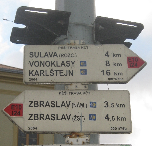
We took the train out to the small town of Radotin, and following lunch in a town centre bar-restaurant, found the route where it passes through Namestí sv Petra a Pavla, the square in front of the parish Church of Radotin, dedicated to St. Peter and St. Paul. It was here that I photographed the sign at the beginning of this post. The little blue and gold scallop shell emblems, show that the route from Zbraslav and heading via Vonoklasy to Karlštejn, is part of the Svatojakubská cesta – the Way of Saint James.

As the sign also indicates, it is a ‘red route’ and therefore waymarked with by red and white marks, very similar to the French balises that mark long distance footpaths in France. At this point, it is also part of a European long distance footpath, the E10. We set out and walked towards Zbraslav, heading back towards Prague. The route took us over this footbridge across the Berounka River. Red and white waymarks were plentiful making the route quite easy to follow.

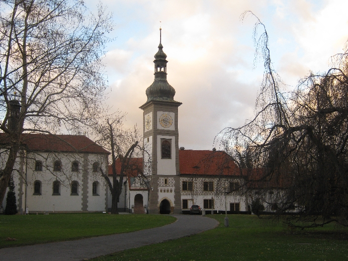
As we walked down a steep wooded path towards Zbraslav, through the trees we were able to see this former monastery below us, with a Church dedicated to St. James – its small tower with a golden orb and cross, is just visible in the photograph. Unfortunately, the whole complex is now in private hands and appears not to be open to the public. I took the photograph below, by putting my camera through the metal gates that keep the grounds around the former monastery, secure from interested intruders 🙁
In the main square of Zbraslav is where unfortunately, waymarking of the pilgrimage route comes to an end. The red route/E10 heads eastwards across a bridge over the Vltava River, whereas the pilgrimage route to/from Prague, remains on the western side of the river. So far as we can establish, there is no waymarking at all between Prague and Zbraslav.
However, there are much more encouraging signs further west. Whilst our German guidebook only describes the route from Prague to Tillyschanz, it does mention an alternative more southerly route, that leaves the one described in the guidebook at Karlštejn, and heads via Príbram and Klatovy, and then crosses the border about six kilometres before reaching the small Bavarian town of Eschlkam. Between Príbram and Klatovy, is the small town of Nepomuk, where my friend Adrian Blank is based, who has regularly helped me with repairs and servicing of my car.
On the outskirts of Nepomuk, there is another Kostel sv. Jakuba / Church of St. James by which this more southerly route passes. When visiting Adrian in January earlier this year, I discovered a display board near the Church with a map showing this pilgrimage route, together with this newly installed sign indicating the distance to Santiago de Compostela.


