Hrad Litice / Litice Castle

Litice Castle © Ricky Yates

In advance of our recent holiday in the Orlické hory, I followed my usual practice and spent some time examining detailed maps of the area, looking for interesting places to walk and to visit. For those who don’t know, my first degree is in Geography and I’ve had a life-long love of maps 🙂

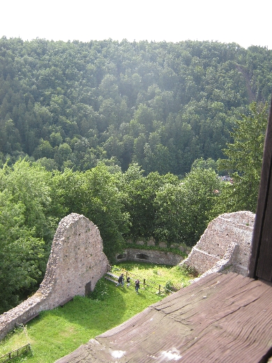
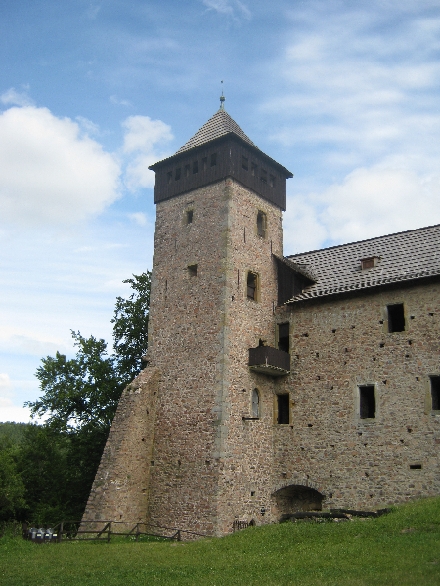
In the southern foothills of the Orlické hory, I spotted a wooded rocky outcrop, surrounded on three sides by the Divorká Orlice – ‘Wild Eagle River’, on top of which were the ruined remains of a castle – Hrad Litice / Litice Castle. It looked like a fascinating place so I put it on my ‘places to visit’ list for our holiday.

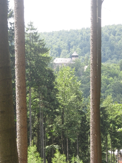
Hrad Litice / Litice Castle was a little too far to walk to from where were staying. So instead, we drove to Popluží, just west of the town of Žamberk, and set out on a circular walk to the castle and back again. I chose the outward route in the hope of getting a view of the castle from a nearby hillside, before dropping down into the village of Litice nad Orlicí itself. As you can see below, I was not disappointed.


Litice Castle from the forest across the valley © Ricky Yates

The castle itself, dates from the thirteenth century and has had a chequered history, reflecting much of the wider history of what is now the Czech Republic. At one point, it was a stronghold of Jirí z Podebrad, a Hussite King of Bohemia. After the defeat of the Protestant forces of the Bohemian Estates by the Catholic League, at the Battle of Bílá hora / White Mountain in 1620, it fell into disuse and disrepair. Repairs were carried out in the latter part of the nineteenth century, and during the 1920s and 1930s, by an Irishman who owned the fortress at that time. He was predominantly responsible for the way the remains of the castle now appear today.

View from the castle tower across the valley of the Divorká Orlice © Ricky Yates

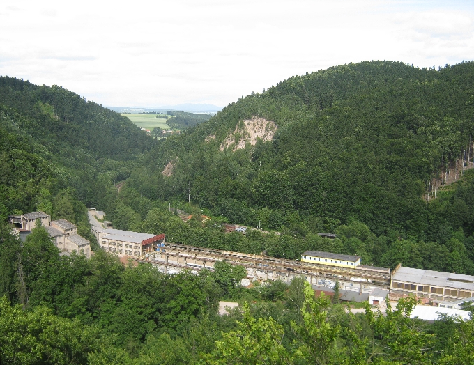
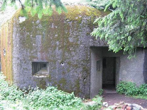
The view from the top of the castle tower is quite spectacular, only spoilt by the neighbouring stone quarry 🙁 However, one always has to remember that if roads and railways are to be built and existing ones maintained, then gravel and stone chips are essential and they have to come from somewhere!

Fortifications at Litice Castle © Ricky Yates

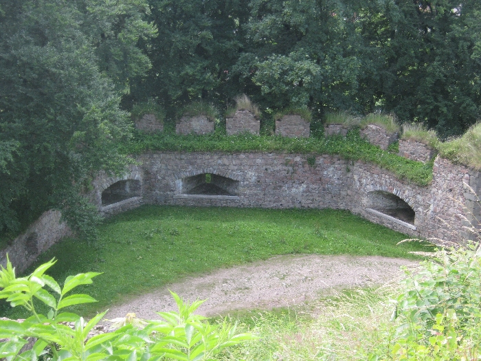
Although only the lower part of much of the castle fortifications now exists, it is still possible to see the thickness of the original exterior walls, with the appropriate orifices from which any surrounding enemy could be fired upon.

Having visited the castle, we returned down the hill to the village of Litice nad Orlicí, and then set out on our return walk along the valley of the Divorká Orlice – ‘Wild Eagle River’, to Popluží, where we had left the car earlier in the day. The combination of a walk through attractive fields and forests, together with a visit to a historic castle, made for a most enjoyable day.

View of the remaining fortifications from the tower of Litice Castle © Ricky Yates

The joys of Czech public transport

Diesel car 'Verunka' © Ricky Yates
Diesel car ‘Verunka’ © Ricky Yates

The Czech Republic has one the most dense rail networks in the whole of Europe. One of the very few benefits of over forty years of communist rule is that nearly all of it is still in existence and in use. Unlike in the UK, where over a third of the rail network was made redundant in the 1960s by Dr. Beeching, no one in the Czech Republic ever saw any part of their rail network as being ‘uneconomic’ and therefore needing to be closed down.

On Friday 28th June during our recent holiday in the Orlické hory, we walked around fourteen kilometres from our hotel in Rícky v Orlických horách, all along a waymarked footpath which follows the valley of the Rícka and Zdobnice rivers. At the end of our walk, we arrived in the village of Slatina nad Zdobnici. How did we get back to our hotel without retracing our steps? By a wonderful combination of train and bus.

The railway station at Slatina nad Zdobnici © Ricky Yates

At the western end of Slatina nad Zdobnici is the village railway station. Here it is in all its glory 🙂 Yes, there is grass growing on the platform and between the railway tracks. But trains still run regularly along the line and a clear timetable was on display. We had a bit of a wait as we had missed the previous train by about fifteen minutes. But right on time, the 14.37 service to Rokytnice v Orlických horách, duly arrived.

Our Czech railway ticket


As on many branch lines of the Czech rail network, the service was provided by a single diesel rail car. Each one has a name and the one we travelled on was called ‘Verunka’. As the station at Slatina is unmanned, the procedure is to buy your ticket from the guard, once you are on board. Here is ours for the grand sum of 34 Kc – £1.12 at current exchange rates. And yes, that is for the two of us – £0.56 each! The ticket also declares the distance to be travelled – nine kilometres.

When we reached Rokytnice v Orlických horách, which is also the end of the line, we could have virtually straight-away caught a bus from outside the station, all the way back to Rícky v Orlických horách. Instead, we walked a short distance to Penzion Rampušák in the centre of the town, in order to have a well-deserved late lunch and do a little supermarket shopping. But at 17.13, right outside the supermarket, along came the next local bus service, to take us the six kilometres back to Rícky, also for the grand sum of 34 Kc. The joys of Czech public transport – regular, efficient and remarkably cheap!


Diesel car 'Verunka' at Rokytnice v Orlických horách station © Ricky Yates
Diesel car ‘Verunka’ at Rokytnice v Orlických horách station © Ricky Yates

Orlické hory

The Orlické hory from Masarykova chata © Ricky Yates

This post will be more pictures than words, in an effort to give a broader overview of the Orlické hory / Adlergebirge / Eagle Mountains. All the photographs are from our recent holiday in the area between Monday 24th June – Tuesday 2nd July. They stand in stark contrast to those illustrating my post from our earlier visit at the beginning of April 2013, in which snow was the predominant feature 🙁

The main mountain ridge of the Orlické hory oscillates between being just under or over 1000 metres above sea level, with Velká Deštiná the highest point at 1115 metres. Most of the mountainside is forested which means much welcome shade when walking and and a very unspoilt natural habitat. The downside is that trees often prevent the visitor from having a clear view over the surrounding area, one of the rewards I expect from climbing a mountain 🙂

Viewing tower on the summit of Anenský vrch © Ricky Yates

In some places, such as here on the top of Anenský vrch (991m), this problem has been overcome by the building of a viewing tower. But when I reached the top of Velká Deštiná (1115m), I discovered that the tower I had seen in a photograph dating from 2001, has since been dismantled and is yet to be replaced.

View across the Orlické hory from the summit of Anenský vrch © Ricky Yates


Masarykova chata © Ricky Yates

The Orlické hory have long been a popular area for walking in summer and skiing in winter. This is the Masarykova chata, opened in 1925 to provide accommodation and meals for visiting tourists and named after Tomáš Garrigue Masaryk, the first president of Czechoslovakia. His bust stands proudly on a pillar in front of the chata. But it was fascinating to see on display, an old black and white photograph dating from the mid-1930s, which described the building as being die Sudetenbaude im Adlergebirge. Yet another illustration of chequered history of this area.

During our walks we also encountered two things we were not expecting to see.


Lavender field © Ricky Yates

Firstly, this amazing field of lavender, which looks as though it belongs in Provence in the south of France, rather than in north-east Bohemia.

Nebeská Rybná Church with the fouth green alongside! © Ricky Yates
Nebeská Rybná Church with the fourth green alongside! © Ricky Yates

Secondly, a recently created nine-hole golf course at Nebeská Rybná, with the fourth green alongside the village Church!

Rícky v Orlických horách © Ricky Yates

Czechoslovak border fortifications

Border fortification in the Orlické hory © Ricky Yates

At the end of the First World War, Tomáš Garrigue Masaryk, President (1918-1935) of the newly declared independent nation of Czechoslovakia, was very keen that the western boundaries of the country should be the historic ones of Bohemia and Moravia which predominantly follow the ridges of the surrounding hills and mountains. This was for two main reasons. The first was to ensure that nearly all Czech speakers would be residing within the new nation. The second was to have borders that were relatively easy to defend, should conflict once more arise in the future.

However, as explained in a blogpost I wrote two years ago, one important consequence of the adoption of these borders was that many people of German ethnic origin were also incorporated within the new nation of Czechoslovakia. According to a census taken in 1921, just over three million Germans lived in Czechoslovakia, accounting for around 23% of the country’s total population. The areas where Germans formed a majority were known as Sudetenland and the people themselves as the Sudetendeutsche.

Soon after Hitler came to power in Germany in 1933, he started making demands for the incorporation of German minorities into a ‘Greater Germany’, in particular the Sudetendeutsche residing in Sudetenland. This alarmed the Czechoslovak government who began to make defensive plans to counteract any future Nazi invasion attempt.

Border fortification in the Orlické hory © Ricky Yates
Border fortification in the © Ricky Yates
Border fortification in the Orlické hory © Ricky Yates

The Orlické hory now lie parallel to the border with Poland, but until 1945, this was the border with German Nieder Schlesien – Lower Silesia. Between 1935-1938, a whole series of defensive fortifications were built here, as can be seen in these photographs. The idea was that, from these positions, any possible invasion could be held in check, until the wider Czechoslovak Army could be mobilised to deal with it.

Border fortification in the Orlické hory © Ricky Yates

It is somewhat ironic that the construction of these defences, created much needed employment for the local population who had been hard hit by the financial crash of 1929 and the economic depression that followed. Yet the majority of these people were themselves, German speakers!

The whole issue of Sudetenland and the Sudetendeutsche, came to a head at the Munich Conference, held at the end of September 1938. In an effort to appease Hitler and avoid conflict, the then British Prime Minister Neville Chamberlain, along with his French counterpart Édouard Daladier, signed the infamous ‘Munich Agreement’, giving Hitler control of the Sudetenland. All this was done without the Czechoslovak government being consulted or represented at the conference.

As a result, all these border fortifications were never used for the purpose for which they were built. Despite Hitler promising that the the annexation of the Sudetenland would be the end of German territorial expansion, six months later, his forces occupied the rest of Czechoslovakia. And because Czechoslovakia had now lost the very defensive borders that Masaryk had insisted upon in 1918, the Nazi Army was able to do so, with hardly a shot being fired.

In the past few years, with the aid of EU funds, a walking trail with information boards has been established, linking the various fortifications and giving an explanation about their construction. The rather large fortification at Tvrz Hanicka, is now a museum.

Whilst walking the trail, I could not help but notice that a linguist choice had clearly been made by someone in authority. Information boards about the geology, geography, flora and fauna of the Orlické hory are in Czech, Polish and German, the three languages most likely to be spoken by visitors to this delightful area. Those explaining the origin of these defensive fortifications, are also in three languages – Czech, Polish and English. I will leave my readers to decide about the significance of this difference.

A refreshment truck at Tvrz Hanicka, covered with camouflage netting!  © Ricky Yates
A refreshment truck at Tvrz Hanicka, covered with camouflage netting! © Ricky Yates

Neratov

Neratov Church © Ricky Yates

Neratov is a small village located on the eastern side of the Orlické hory, in the valley of the Divorká Orlice – ‘Wild Eagle River’, which forms the border between the Czech Republic and Poland. Between 1723-33, a large baroque Church was built here, to house a statue of the Virgin Mary that had been previously donated by the parish priest of Rokynice v Orlických horách, situated on the other side of mountain range. Thus Neratov became a place of pilgrimage and Marian devotion.

The Church, built on a rocky promontory overlooking the village, is most unusual in one particular aspect. It has a north-south, rather than the traditional east-west, axis. The only other Church I know built in this manner, is the new Coventry Cathedral, which is at right-angles to the old ruined Cathedral.

On 10th May 1945, two days after the Second World War was supposed to have come to an end, the Church was hit by a Soviet Red Army anti-tank rocket and was gutted by fire. The roof and interior fittings were completely destroyed, just leaving the exterior walls standing. Then in 1957, some supporting arches collapsed. In 1973, an order was issued for the demolition of the ruined remains and the only reason the building survived, was because the local communist authorities, lacked the finances to put the demolition order into effect 🙂

Neratov 2
The new glass roof of Neratov Church © Ricky Yates

Following the Velvet Revolution of 1989, moves began to be made to preserve and then restore the Church. In 1992, it was declared the equivalent of a British ‘listed building’. Then in 2006-2007, it was completely re-roofed. This has been done in the most imaginative way with timber framing supporting clear glass, allowing a remarkable amount of light into the interior of the Church. The money to carry out the restoration came from a variety of sources including Germany. This website in German, is maintained by supporters of the project. It uses the name Bärnwald, which is how the village is known in German.

The interior of Neratov Church © Ricky Yates

Both Sybille and I very much enjoyed our ‘pilgrimage’ to Neratov – we did walk around 15 km from Rícky v Orlických horách to get there! Unlike so many Czech Churches, Neratov Church is kept open during daylight hours. Also, because of the 1945 fire, unlike so many baroque Churches in Prague and elsewhere in the Czech Republic, the interior walls are plain with just a large crucifix on the north wall behind the altar, and a small new statue of the Virgin Mary in the north-west corner. It is very hard to find the right words to articulate the real sense of peace and holiness that I felt whilst being there.

The village itself has also been brought to life by the Neratov Association, which has provided sheltered housing and employment, for people with light to medium mental handicaps. As explained in a small colour leaflet that I picked up in the Church, ‘the aim is to help these people to live a free, independent, and responsible life with the support of a team of assistants in a friendly family-like environment’.

Neratov 4
Jesus asking questions of his twelve disciples © Ricky Yates

I suspect that these figures, sitting in front of the lectern in the sanctuary of the Church, are the work of some of those in the care of the Neratov Association. The text in Czech, of Luke 9. 18-20, was on display alongside them. Jesus is asking first, ‘Who do the crowds say I am?’ And then more pointedly, ‘Who do you say I am?’

Our visit to Neratov was the first of several days of fascinating discoveries, as we explored the Orlické hory. I hope to write and post more about our experiences in the coming days.