It is three and a half years since I wrote a blog post about the third member of our family – Oscar the cat. Other than an occasional passing mention, he hasn’t since really featured here very much. So I thought it was time he once more deserved his own post.
These days, we refer to Oscar as our ‘senior cat’ as he is now nearly sixteen and a half years old. This is a very good age for a cat and in many respects, it is quite remarkable that he is still with us.
Whilst Oscar has never been a large cat, we began noticing earlier this year, that he seemed to be getting thinner. We tried feeding him cream and other goodies, in an effort to fatten him up. He also was failing to groom himself as he did in the past, with Sybille resorting to catching him and brushing him herself, to try and keep his fur in order. And increasingly, his breath smelt somewhat unpleasant.
All of this we put down to Oscar getting old. However, whilst I was in the UK for a few days in early July, Sybille managed, without losing blood 🙂 , to get a closer look at Oscar’s mouth and realised that there was a major build up of tartar on his teeth which needed attention and was clearly the source of his increasingly bad breath. So on my return to Prague, I made contact with the vet, who fortunately speaks fluent English and German as well as Czech, to ask whether he would be willing to treat Oscar’s teeth – treatment which would certainly involve giving him a general anaesthetic, bearing in mind his advanced age.
In his reply, the vet said that they would first want to carry out a complete geriatric profile, to assess Oscar for treatment. But if that was satisfactory, they would then carry out the necessary dental work. All this could be done the same day, meaning only one journey to the vet’s surgery, bearing in mind how much Oscar dislikes car travel. So Oscar was booked in for his profile and possible treatment, on Thursday 25th July.
The geriatric profile was comprehensive, involving a clinical examination, the taking of blood for a series of tests, an abdominal ultrasound and a thoracic X-ray. The X-ray revealed abnormalities in the shape of Oscar’s sternum which the vet thinks are due to old fractures. We can only think that these might have occurred when he went walkabout for two months in the summer of 2007. Fortunately, there was nothing revealed to prevent the administration of a general anaesthetic, so one was duly given and five rotten teeth were then extracted.
However, what the blood tests did reveal, is that Oscar is suffering from an over-active thyroid – in fact a very over-active thyroid! This is the explanation as to why he had become so thin. Therefore three weeks ago, he started taking a prescribed methimazole tablet twice a day, to help bring his ‘T4 values’ back to more normal levels. The results have been phenomenal, so much so, we now have a very healthy ‘fat cat’ as you can see in the photo I took of him yesterday, sitting on the mat by the door to the main balcony, enjoying the sunshine.
Anyone who knows Oscar, despite him mellowing in recent years, will realise that getting him to swallow a tablet, it no easy task. But Sybille has discovered the foolproof method – wrap it in a small piece of ham! It then goes down a treat 🙂 Bearing in mind that he will need this medication for the rest of his life, we are clearly going to also need a constant supply of ham. And judging by the healthy cat we now have, who is also once more grooming himself far better than before, it looks like Oscar is going to be with us for a few more years yet.
On Monday 29th July, I conducted my first wedding of 2013, when Daniel, the British bridegroom, married Iva, his Czech bride, at Bouzov Castle. The castle lies in the rolling wooded hills of Moravia, about thirty minutes drive north-west of Olomouc.
As long-standing readers of my blog may know, this was not the first time I have conducted a wedding at Bouzov Castle. For I conducted my first-ever wedding in the Czech Republic at this same venue just over four years ago, also between a British bridegroom, Lea, and his Czech bride, Petra. You can read all about it and see the photos, here.
It was finding this post about Lea and Petra’s wedding on my blog, that prompted Daniel to contact me earlier this year, asking if I would be willing and available to conduct their wedding. As with Lea and Petra, Daniel and Iva had met whilst both living in the UK, but were very keen that their wedding should take place near to Iva’s Czech family home. What I really liked about Daniel’s initial email enquiry to me was his declaration that, ‘Faith is an important and growing part of our lives’, and how he then went on to explain that they were attending an Alpha Course being run by their local Anglican Church on the the Staffordshire/Cheshire border, where they currently live.
I was able to meet with Daniel and Iva earlier in February this year, whilst they were visiting Iva’s family, following a week of snowboarding down the Austrian Alps! But a lot of planning for the wedding service has taken place by email, over the past few months. As with both of my English-speaker to Czech weddings in 2012, it was very important to make sure that both the English and Czech speakers could understand and follow the service. So I was most grateful that my friend and Brno service coordinator Katka Bánová, was able and willing to help me on the day.
It has to be said that my journey from Prague to north Moravia, got off to the worst of possible starts. My plan was to drive there, following our Eucharist in Prague on the morning of Sunday 28th July. Daniel had already booked and paid for me to stay overnight in a hotel on the outskirts of Olomouc, where many other guests were also staying in advance of the wedding.
Additionally, I had arranged to drive on further on Sunday afternoon/evening, to Kuncice pod Ondrejnikem, in order to meet a Czech young lady called Dagmar, who currently lives and works in Portsmouth, but was home visiting her family. Dagmar is currently exploring a possible vocation to train for ordained ministry in the Church of England and has been in email contact with me. This was to be our first chance to meet in person, rather than just online.
Therefore, instead of travelling into St. Clement’s from the Chaplaincy Flat by public transport, as we normally do, I instead drove in by car, with all my necessary gear for being away for two nights, to which I was to add my cassock-alb and stole, following the Prague service. Unfortunately, just after crossing the Vltava River and waiting to turn left into Lannova, where it is possible to park the car free-of-charge on a Sunday, the car engine died!
Four police officers kindly pushed the car to a parking place outside the nearby Clarion Hotel and told me to go and ‘take my mass’ 🙂 and then come back to the car afterwards. So I duly did, but was at a total loss as to how I was to then fulfil my commitments both to Dagmar and to Daniel and Iva.
Aided by a member of the congregation and one of the hotel staff, we were able to push the car to a nearby parking place where it was free-of-charge to park until 08.00 on Monday morning. Then, to cut a long story short, I eventually combined my hanging clothes with my cassock-alb and stole over one arm, and put all my other belongings in a bag and carried them in my other hand, and headed by tram to Prague’s main railway station.
All this happened during one of the hottest and most humid periods of weather I have ever experienced in Prague. Therefore on arrival at the railway station, I happily paid CZK 20 (£0.66), to avail myself of a toilet cubicle, in order to change out of my black clerical shirt which was covered in white perspiration stains, into something dryer and more comfortable. I also did get my money’s worth and used the facility for the purpose for which it was primarily intended 🙂
Such are the joys of public transport in the Czech Republic, that even on a Sunday, there is an hourly train service between Prague and Olomouc. Thus I arrived safely in the centre of Olomouc just before 18.00 that evening, and a short taxi journey took me to my hotel. En-route, I texted Dagmar, to apologise for not being able to meet her.
The next morning, I made contact by email and phone, with an English-speaking staff member of our local Renault Garage. He kindly organised a tow truck to pick up the car before it got a parking ticket, and even arranged for the truck to call first at the Chaplaincy Flat, to pick up the spare car key from Sybille. With that all finally sorted, I was then able to concentrate on the wedding.
Katka kindly picked me up from the hotel and drove us both to Bouzov Castle in advance of the rest of the guests who were travelling there by private coach. This gave us plenty of opportunity to talk through how we would conduct the service and sort out all of the practicalities, well in advance of the event. Consequently, the service went extremely smoothly. As with both my English-speaker to Czech weddings in 2012, I had many guests afterwards expressing enjoyment of the service, especially Czech speakers who appreciated all that had been done to ensure they understood and could follow what was being said.
The reception took place under a marquee within the castle courtyard. This was possible because of the wedding taking place on a Monday when the castle is closed to the public. The couple were made to fulfil various Czech marriage traditions, some of which I’ve written about previously. One is the requirement to feed soup to each other from a single bowl, while protected by a sheet. The idea is to encourage cooperation between the newly married couple.
Other traditions are more universal in nature such as cutting the wedding cake. As you can see, not only did Daniel enjoy cutting the cake, he also enjoyed consuming some of it!
Despite all of the hassles I experienced on the Sunday, I still did enjoy being part of Daniel and Iva’s special day. The happy couple are hoping to relocate to the Czech Republic in the not so distant future and have assured me that they want to become part of either the Prague or Brno Anglican congregations.
As for the car, the problem was the failure of the alternator, meaning the engine was no longer charging the battery. Combined with the replacement of both metal straps under the petrol tank, work strongly recommended when the car passed its STK in June, together with being towed, I ended up with a bill for CZK 11,157 (approx £372.00). The better news is that I still managed to meet up with Dagmar, as she came to Prague to see her cousin and we managed a chat over a couple of beers, last Friday evening.
On Tuesday 2nd July, Sybille and I returned to Prague from our eight day holiday in the Orlické hory. The next afternoon, having managed to wash, dry and iron all our dirty clothes, I was off on my travels again, heading for Václav Havel Airport, as Prague Airport is now officially known, in order to spend the next five days in the UK – only my fourth visit there since moving to Prague nearly five years ago.
As on my previous visit just under a year ago, I flew with the budget Hungarian airline Wizz Air, from Prague to Luton Airport. Having landed at Luton on time at 15.30, collected my bag, got through passport control, remembering to say ‘Good afternoon’ and not ‘Dobrý den‘, I set foot outside the airport terminal, to once more experience a country in which I feel less comfortable, the longer I am away from it.
Before I fell asleep that evening, I had three ‘I know I’m in the UK’ experiences. The first came once I stepped aboard the shuttle bus to take me from the airport, to the car park at Slip End where I was to pick up my hire car. I had to listen to a long announcement all about what to do, should the bus be involved in an accident or catch on fire. All this for a five minute bus journey! Sadly this is health and safety gone mad, coupled with lawyers who offer to sue anyone you can think of to blame, for anything that might ever happen to you.
The second experience occurred that evening, after I had driven from Slip End, up the M1 to Nottingham, and met up with my son Phillip and his girlfriend Lisa. Whilst we were sitting in a pub restaurant around the corner from where Phillip lives, I overheard a bit of the conversation taking place on the table next to us. “They’re talking in English”, I thought to myself. It took a few seconds before it registered with me that this should not be surprising as I was actually in England 🙂
The third experience was a very positive one. Having finally worked out how to log on to the wifi network at Phillip’s current home, I accessed the BBC News website, to catch up with the day’s news events. It was a great pleasure for once, not to have any advertising anywhere on the site, because I was accessing it in the the UK, rather than in the Czech Republic.
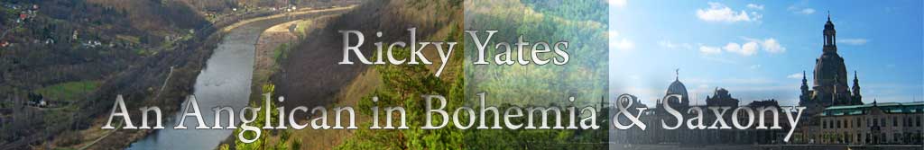
Phillip kindly took Friday 5th July as a day of his annual leave, and spent it taking me on a walking tour of Nottingham. In many respects, it might be better described as a pub-crawl of Nottingham, though it was a very warm day so we did have a good excuse 🙂 We visited the ‘Trip to Jerusalem’ which claims to be the oldest inn in England. And we had lunch in a most pleasant location, sitting alongside Castle Lock on the Nottingham Canal, outside ‘The Navigation’, where Phillip took this picture of me.
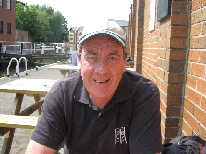
After lunch, we walked along the canal towpath to where the canal rejoins the River Trent. On our walk, we passed this heron, sitting on the base of a bridge parapet, no doubt on the lookout for his lunch!
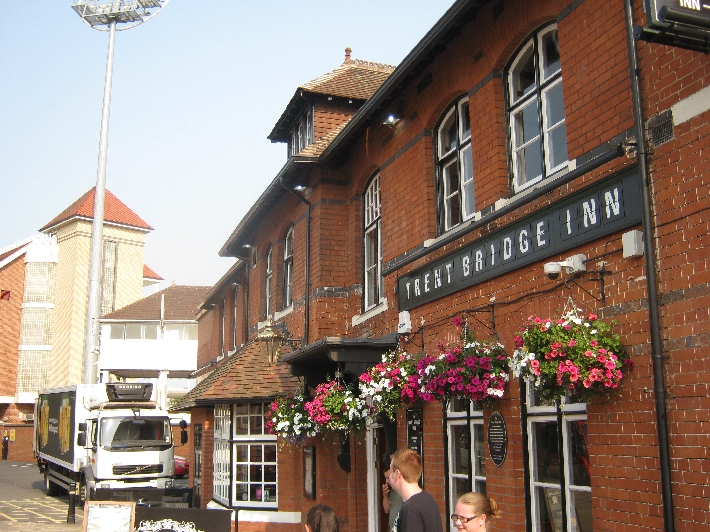
We then walked across the main bridge over the River Trent to the Trent Bridge Cricket Ground and the neighbouring world-famous Trent Bridge Inn. Banners were already out on nearby lamp posts, advertising the commencement of the Ashes Test Match series against Australia which was due to begin here on the following Wednesday. But as we enjoyed a pint sitting in the TBI, the sport on the TV screen was tennis, as we watched Novak Djokovic win his Wimbledon semi final match against Juan Martín del Potro.
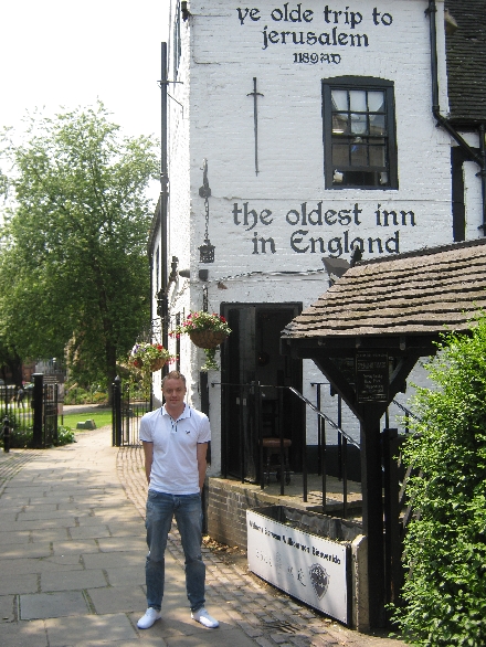
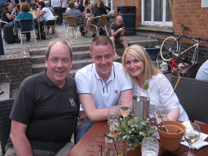
Later, we joined Lisa and some of hers and Phillip’s work colleagues, for another cool beer/glass of wine outside in the Friday evening Nottingham sunshine. My thanks to Natasha, (I hope I remembered the name correctly), for taking this photo of the three of us.
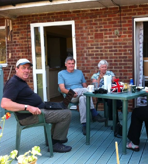
I spent the weekend of 6th -7th July, staying with my daughter Christa and son-in-law Ian, at their home in Daventry, Northamptonshire. Christa did ask me not to post a photograph of her here on my blog, so instead, here is a photograph taken by Ian, of me and his mother Eileen and step-father Barry, sitting on the decking at the rear of Christa and Ian’s home. The reason for the computer on my lap was to show some photographs – I wasn’t working, honest!
Having said that, I did have somewhat of a ‘busman’s holiday’ on Sunday morning. I preached at two services – in St. Mary the Virgin, Wilby and St. Nicholas, Great Doddington, on behalf of the Intercontinental Church Society (ICS), who have financially and prayerfully supported the Prague Chaplaincy since 2000. These two parishes on the outskirts of Wellingborough, in turn, support the work of ICS. It was wonderful to meet people who faithfully pray for us in Prague. In turn, they enjoyed meeting and hearing me in person, rather than just knowing of me through a photograph in the ICS magazine.
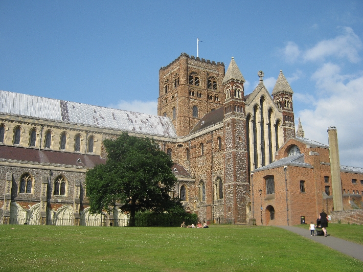
With a few hours to kill before my flight back to Prague on the evening of Monday 8th July, I revisited somewhere that has a special place in my own spiritual journey – the Cathedral and Abbey Church of St. Alban, to give what is commonly known as St. Albans Cathedral, its correct, full name. Here, just over twenty-four years ago on 2nd July 1989, I was ordained deacon, and a year later on 1st July 1990, ordained priest.
The original Abbey Church was built on the site of where Alban, the first English Christian martyr, was put to death for his faith. It is quite a number of years since I was last here and it was wonderful to be able to both pray privately in the Cathedral, as well as to attend Evensong, before heading back to Slip End to return the car, and then to Luton Airport to fly home.
In advance of our recent holiday in the Orlické hory, I followed my usual practice and spent some time examining detailed maps of the area, looking for interesting places to walk and to visit. For those who don’t know, my first degree is in Geography and I’ve had a life-long love of maps 🙂
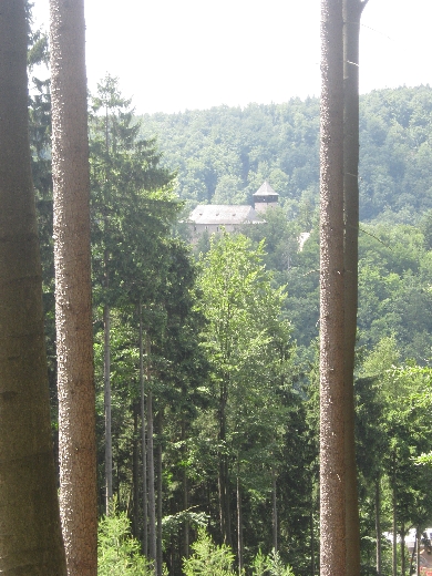
In the southern foothills of the Orlické hory, I spotted a wooded rocky outcrop, surrounded on three sides by the Divorká Orlice – ‘Wild Eagle River’, on top of which were the ruined remains of a castle – Hrad Litice / Litice Castle. It looked like a fascinating place so I put it on my ‘places to visit’ list for our holiday.
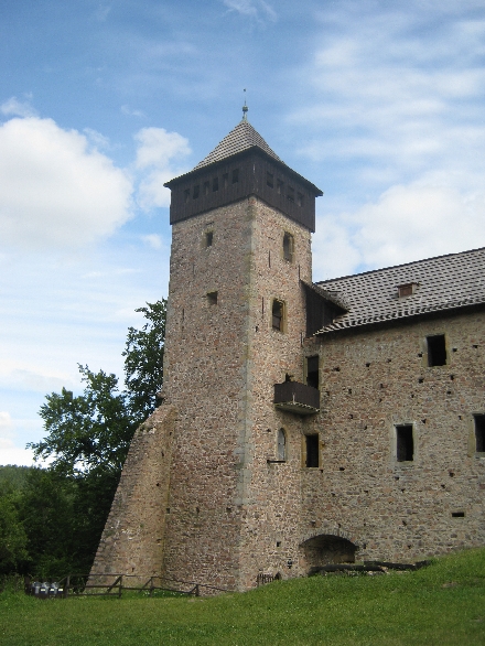
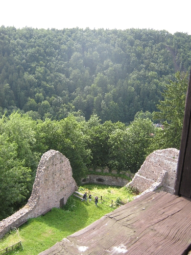
Hrad Litice / Litice Castle was a little too far to walk to from where were staying. So instead, we drove to Popluží, just west of the town of Žamberk, and set out on a circular walk to the castle and back again. I chose the outward route in the hope of getting a view of the castle from a nearby hillside, before dropping down into the village of Litice nad Orlicí itself. As you can see below, I was not disappointed.
The castle itself, dates from the thirteenth century and has had a chequered history, reflecting much of the wider history of what is now the Czech Republic. At one point, it was a stronghold of Jirí z Podebrad, a Hussite King of Bohemia. After the defeat of the Protestant forces of the Bohemian Estates by the Catholic League, at the Battle of Bílá hora / White Mountain in 1620, it fell into disuse and disrepair. Repairs were carried out in the latter part of the nineteenth century, and during the 1920s and 1930s, by an Irishman who owned the fortress at that time. He was predominantly responsible for the way the remains of the castle now appear today.
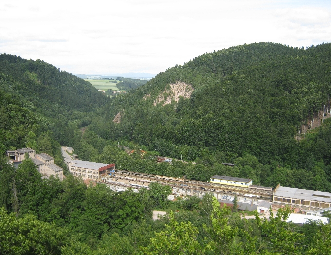
The view from the top of the castle tower is quite spectacular, only spoilt by the neighbouring stone quarry 🙁 However, one always has to remember that if roads and railways are to be built and existing ones maintained, then gravel and stone chips are essential and they have to come from somewhere!
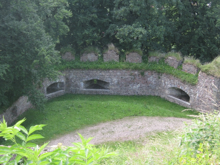
Although only the lower part of much of the castle fortifications now exists, it is still possible to see the thickness of the original exterior walls, with the appropriate orifices from which any surrounding enemy could be fired upon.
Having visited the castle, we returned down the hill to the village of Litice nad Orlicí, and then set out on our return walk along the valley of the Divorká Orlice – ‘Wild Eagle River’, to Popluží, where we had left the car earlier in the day. The combination of a walk through attractive fields and forests, together with a visit to a historic castle, made for a most enjoyable day.
The Czech Republic has one the most dense rail networks in the whole of Europe. One of the very few benefits of over forty years of communist rule is that nearly all of it is still in existence and in use. Unlike in the UK, where over a third of the rail network was made redundant in the 1960s by Dr. Beeching, no one in the Czech Republic ever saw any part of their rail network as being ‘uneconomic’ and therefore needing to be closed down.
On Friday 28th June during our recent holiday in the Orlické hory, we walked around fourteen kilometres from our hotel in Rícky v Orlických horách, all along a waymarked footpath which follows the valley of the Rícka and Zdobnice rivers. At the end of our walk, we arrived in the village of Slatina nad Zdobnici. How did we get back to our hotel without retracing our steps? By a wonderful combination of train and bus.
At the western end of Slatina nad Zdobnici is the village railway station. Here it is in all its glory 🙂 Yes, there is grass growing on the platform and between the railway tracks. But trains still run regularly along the line and a clear timetable was on display. We had a bit of a wait as we had missed the previous train by about fifteen minutes. But right on time, the 14.37 service to Rokytnice v Orlických horách, duly arrived.
Our Czech railway ticket
As on many branch lines of the Czech rail network, the service was provided by a single diesel rail car. Each one has a name and the one we travelled on was called ‘Verunka’. As the station at Slatina is unmanned, the procedure is to buy your ticket from the guard, once you are on board. Here is ours for the grand sum of 34 Kc – £1.12 at current exchange rates. And yes, that is for the two of us – £0.56 each! The ticket also declares the distance to be travelled – nine kilometres.
When we reached Rokytnice v Orlických horách, which is also the end of the line, we could have virtually straight-away caught a bus from outside the station, all the way back to Rícky v Orlických horách. Instead, we walked a short distance to Penzion Rampušák in the centre of the town, in order to have a well-deserved late lunch and do a little supermarket shopping. But at 17.13, right outside the supermarket, along came the next local bus service, to take us the six kilometres back to Rícky, also for the grand sum of 34 Kc. The joys of Czech public transport – regular, efficient and remarkably cheap!