Tomorrow will be my sixty-fourth birthday. Yes – on 26th February 1952, in the upstairs bedroom of a semi-detached house in Allesley, Coventry, UK, Yours Truly made his entry into the world. Of course, if I had arrived three days later, then it would only be my sixteenth birthday as 1952 was a leap year 🙂 , just like 2016.
The reason I was born at home and not in hospital, was because my two older sisters had been born in hospital. My mother had had no problem with either delivery so was told that baby number three could be born at home. My mother was under the care of her district midwife, a situation which is now much more widely understood by the younger generation, because of the TV series ‘Call the Midwife’. However, I chose to enter the world on my mother’s district midwife’s day-off, meaning that a colleague covering for her, had to assist with my delivery.
Unlike 25th February 2015, when Sybille and I celebrated our joint birthdays with a delightful meal at Sansho, I cannot celebrate with her today, as she is currently in Spain, walking the Via de la Plata from Seville to Santiago de Compostela. So instead, I sent greetings to her by Skype yesterday, wishing her both ‘Happy Birthday’ and ‘Alles gute zum Geburtstag!‘ I’m sure she will return the compliment to me tomorrow. And I have been invited out to lunch tomorrow, in honour of my birthday.
Whilst my birthday tomorrow is not a landmark one with a zero at the end, it still has great significance. Why? Because it means that in exactly one year’s time, both the Church of England and the state, will allow me to retire if I choose to do so. Whilst because of increased human longevity, retirement ages are being raised for younger people, it doesn’t really affect me, because of my age.
I probably will not retire in exactly a year’s time. However, my current Bishop’s Licence as Chaplain of St. Clement’s, Prague, only goes to the end of April 2017. Therefore sometime between my sixty-fifth birthday on 26th February 2017 and the expiry of my Bishop’s Licence on 30th April 2017, I will retire – the exact date to be decided in the next few months.
The other major decision to be made is where to retire to. That is a big issue to be resolved sometime this summer. In the mean time, I end this post with a song that I’ve been whistling and singing the past few weeks in anticipation of tomorrow. Rather than the original from The Beatles, here’s a fun version by a male voice choir.
In early December this year, my current British passport will expire. As the United Kingdom does not issue identity cards to its citizens, my passport is the only accepted form of ID that I have whilst living in continental Europe. In 2016, I will be travelling to the UK twice, as well as to Poland for the Eastern Archdeaconry Synod, not forgetting my now monthly trips to Dresden. All of this is before thinking about where Sybille and I might want to go on holiday together!
The Foreign and Commonwealth Office website states that I must allow four weeks from my application and supporting documentation, including my current passport, arriving at the Passport Office in the UK, before I can expect to receive my new passport. During that time, I will be unable to travel anywhere beyond the borders of the Czech Republic. As a consequence, these past few days I have been studying my diary, trying to work out when on earth there is a time-slot of at least four weeks, when I will not need to travel.
Recently, several people have said to me, ‘Surely you don’t need your passport just to travel to Dresden and back on the train?’ For them, and for any one else thinking along these lines, I will recount my rather ‘interesting’ experiences when travelling back to Prague today, having led and preached at the English-language Anglican Evening Prayer service at the Frauenkirche, Dresden, yesterday evening.
Having boarded my train at Dresden Hauptbahnhof, I found myself a seat in a compartment where the only other passenger was a young lady of Asian appearance. Soon after the train set off, two burly German Polizei walked along the corridor and outside our compartment, stopped two young German men walking in the opposite direction, and asked to see and check their respective IDs. Having done this, rather than walking on down the train as I expected, they instead entered our compartment and asked to see our passports.
I duly produced mine which was then subjected to a thorough examination. Herr Polizei held it up to the light to check for watermarks and the like. I think he was also a little dubious because, being nearly ten years old, it isn’t biometric. Noticing the stamp of the Czech Foreign Police granting me ‘Temporary residence’ that is ‘neomezený/unlimited’, he asked, in English, if I lived in Prague. I gave him quite a shock when I spoke back to him in German 🙂 My passport was returned to me 🙂
However, the young lady got a complete grilling. It didn’t help her cause that she appeared to neither speak German or English – or if she did, she was too shy to do so. And if I dare say so – because she wasn’t white Caucasian 🙁 Both Polizei didn’t think her passport photo looked like her. They insisted she took off the large scarf around her neck so they could compare her skin colour with that in the photograph. The also studiously studied the visa in her passport, (presumably a Schengen one), querying its validity.
There followed a phone call to headquarters, checking her details, with the whole business lasting around fifteen minutes, before she was finally given the all clear and her passport was returned. One funny side effect of all this was that neither of us ever got our tickets checked. The female ticket inspector came past twice, but because of the police presence, she left us in peace!
When the train arrived at the Czech border town of Decín, a tall blonde Czech young lady joined us in the compartment. Decín is also where the Deutsche Bahn train staff get off and are replaced by those of Ceskédráhy. Presumably both Polizei officers got off too.
However, shortly after the train left Decín, who should come along the corridor and open the compartment door – two Czech Policie! The Czech young lady flashed her Czech ID card out of her purse at the same time as flashing her mascaraed eyelids, and she was immediately told that all was fine 😉 The inspection of my passport and Czech residency document took a little longer but no query was raised. But the poor Asian young lady had her passport looked at, photograph and actual likeness compared, visa examined. It wasn’t quite the third degree of the German Polizei, but still lasted at least three minutes.
Therefore after today’s journey, I have no intention whatsoever, of travelling to Dresden and back, without a passport. The mind boggles what would have happened if I’d tried to do so today.
But not only do I have to find a minimum four week time slot when I can be without a passport, I also have to make a deep hole in my bank account to pay for the new one. A ten-year British passport now costs £83.00, together with a further £19.86 in courier delivery charges – £102.86 in total. And I have find a safe way, no doubt also expensive, of getting my application and associated documentation to the Passport Office in the UK to start the process 🙁
And to answer those who have said, ‘Can’t you get a temporary passport whilst your new one is being issued?’ Yes – it is possible to get an ‘Emergency Travel Document’, but – costing another £95.00!!!!
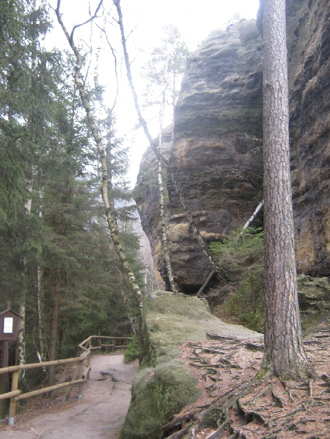
On Monday 15th February, I took a proper ‘day-off’ and went for a near 20km walk in Ceské Švýcarsko – Bohemian Switzerland, the beginning of keeping the promise I made at the end of my previous but one blog post. I saw enough during my day trip, to encourage me to return and further explore this attractive area.
I drove north-west from Prague, to the port town of Decín on the Labe River, and then a further 12km north alongside the Labe, (which becomes the Elbe on entering Germany), to the border settlement of Hrensko. Here I turned onto a minor road along the Kamenice river valley to the eastern end of the settlement, where there was a designated car park in which I duly parked the ‘Carly’. According to a sign, its costs CZK 30 per hour to park, or CZK 120 for the day. But being a Monday in February, there was no attendant waiting to collect my fee!
Hrensko basically consists of hotels and other forms of accommodation, together with several bar-restaurants, all aimed to meet the needs of the visiting walker and tourist. Unfortunately, because of its proximity to the German border, it also has a number of ‘night clubs’ which are little more than euphemisms for brothels. These are almost exclusively patronised by visiting German males, especially at weekends.
From where I parked the ‘Carly’, I first walked for over 1.5km along a minor tarmac road, following the waymarking for the red walking route, to a point where the red route leaves the road and climbs up into the hills. I was glad I hadn’t followed my original instinct and driven to this point and tried to park, because there was a large sign saying that doing so, would result in a CZK 5000/£145.00 fine. It was either park back where I was parked, or alternatively a further 3km further on.
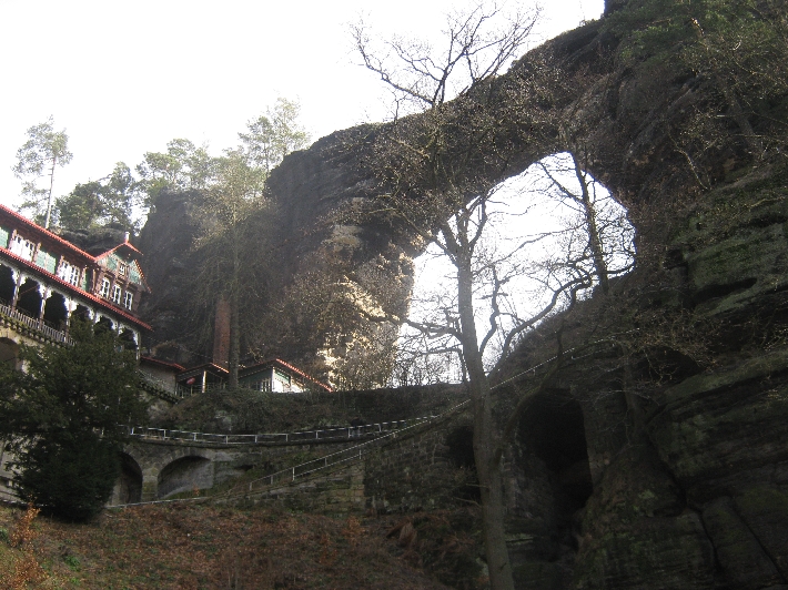
Climbing the red route took me to the most famous feature of Ceské Švýcarsko – Bohemian Switzerland – Pravcická brána. It has a span of 26.5 metres, an inside height of 16 metres, 8 metre maximum width and 3 metre arch and is the largest natural sandstone arch in Europe.
In the latter half of the nineteenth century, a hotel and restaurant was built alongside this amazing natural feature, as you can see on the left of my photograph. These days, it functions as a National Park information centre and restaurant. Between November and March, it is only open at weekends meaning I couldn’t reward myself with a cool beer after my steep climb. Quite how supplies are delivered to the place I have no idea as there is no access road – just the footpath.
I met or passed a small number of other walkers on this route, all of whom were Germans! My ‘Dobrý den’ was greeted with blank looks, whilst ‘Guten Tag’ gained a positive response 🙂
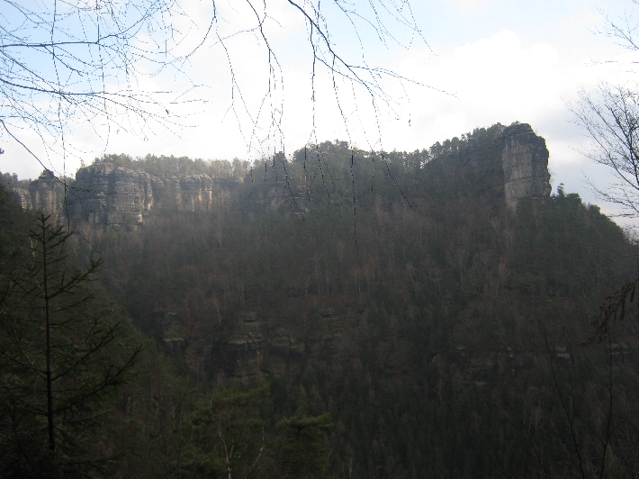
Having descended 500m from Pravcická brána, I continued eastwards along the red route for a further 6.5km. This first gave me a rear view of the sandstone arch.
…….and a series of amazing views. Unfortunately, at this point, my camera batteries decided to die so I have no further photographs.
The route itself was occasionally undulating but mainly level, until the last couple of kilometres when it descended to the small village of Mezní Louka. Walking this route I only met one other couple, coming in the opposite direction. Otherwise, I had the whole of the wilderness to myself.
I made my return journey to the ‘Carly’, first walking a green waymarked route along a minor road to the village of Mezná. Then it was the yellow waymarked route along a gravelled forestry track, finally followed in the reverse direction, by the same 1.5km minor road that I’d set out along several hours earlier.
During the coming week, on Thursday 4th February, this blog celebrates its seventh birthday. I published my first ever blog post here, on 4th February 2009, four-and-a-half months after we arrived in Prague on 19th September 2008.
With this one, there are now 342 posts on the blog. But I do have to confess that the past twelve months have been the least productive year of the blog’s existence, with only 37 new posts being added. The previous lowest total was 41 in 2011-12. However, if you go down the right-hand sidebar to ‘Archives’, and then click on ‘Select Month’, you will discover that I have published at least one blog post in every one of the eighty four months since February 2009 – no mean achievement!
I don’t normally go around blowing my own trumpet, but I do have to say that I am quite proud of the blog and having kept it going for seven years. In my time of blogging, I’ve seen several other blogs started, which have then died after two or three posts. Others, that have gone for a while longer, and then ground to a halt. I am determined that this isn’t going to happen to me, though I acknowledge that it nearly did in 2015, when I only managed to publish four posts in the three months of July, August and September.
Much as I enjoy writing the blog, I do find it quite time-consuming at times. I try to write in interesting but coherent English, with correct spelling and punctuation, and doing so takes time. And when I am stating facts or re-telling history, I also want to be sure that what I write is accurate and true, which means regular visits to my bookshelves & Wikipedia 🙂
Looking ahead, as my blog enters its eighth year, I am sure I will have plenty of things to continue blogging about. After Lent and Easter, I shall be in the UK for nearly two weeks, visiting family and friends and then attending this year’s ICS Chaplains Conference. I have three English-speaker – Czech weddings at which to officiate in 2016, which are always enjoyable as well as fascinating occasions. At the end of September, I will be in Warsaw for the 2016 Eastern Archdeaconry Synod. And at the end of July, there is another very important wedding too….
Likewise, I have not forgotten the promised post(s) about walking with Sybille, from Görlitz to Kamenz, along the first part of Der Ökumenische Pilgerweg in Germany, last August. This remains uppermost in my mind because I hope we will walk the next section, some time later this year. And I do have brewing, a post on the proposed ‘In/out referendum’ that the UK has been promised by David Cameron.
My thanks to all those of you who regularly visit and read my blog, especially the small number of faithful ones who also take the trouble to leave comments, rather than just clicking ‘like’ on the link posted on Facebook. Do join me in raising a glass to wish ‘Ricky Yates – an Anglican in Prague’, a happy seventh birthday!
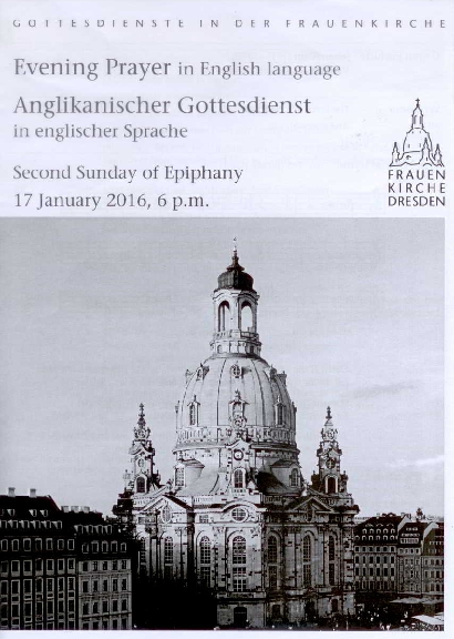
On Sunday 17th January 2016, I conducted worship in two different countries, something I shall now be doing quite regularly in 2016 on the third Sunday of each month. At 11.00, I celebrated the Eucharist and preached at St Clement’s Anglican Church in Prague. Then at 18.00, I led a service of Evening Prayer in the Frauenkirche, Dresden.
Over the weekend, we had a further serious snowfall, so this was the scene that greeted me as I arrived outside St. Clement’s, waiting for our host Czech Protestant congregation to finish their service. It was still snowing when I took the photograph.
From the second week in January, through to around the second or third week of March, Prague enters what I always refer to as the ‘non-tourist season’. It is the time when you can walk around some of the popular historic sights in Prague, without being run over by hordes of visiting tourists. However, tourists are a great boon to us as a Church as, on most Sundays, the congregation is boosted numerically by visitors. Some of them also contribute quite generously to the collection. But for the second Sunday running, we had no visitors at all in the congregation – I knew everybody by name. Clearly we are in the ‘non-tourist season’!
We were therefore, a slightly smaller congregation than usual, with the weather and winter ailments, preventing some people from attending. But nearly all those who did come were very un-Anglican – they sat together in the front pews! Being regulars, they knew where the limited under-pew heating is most effective 🙂
After warming up at Coffee Hour and enjoying post-service refreshments in the hall across the street in Klimentska 18, I then headed off on a short three-stop tram journey to Praha hlavní nádraží (Praha hl.n.) – Prague main railway station, in the company of my friend and ministerial colleague, Rev’d Dr Karen Moritz. I had invited Karen to be the preacher at the January English-language Anglican Evening Prayer service in the Frauenkirche, in advance of her leaving Prague in the next few months.
Upon arrival at Praha hl.n., I immediately checked the departures board, to see whether the platform number for our train to Dresden Haupbahnhof (Dresden Hbf), was displayed. Unfortunately there was no platform number but instead, a note that departure would be delayed by thirty minutes. The train was coming from Budapest and presumably had experienced problems with the adverse weather conditions en-route.
Sitting on the station concourse, constantly scanning the departures board, I increasingly began to panic that we wouldn’t make it to the Frauenkirche on time. Finally, we were summoned to platform six, and the train that was meant to set out at 14.27, departed just after 15.00. Fortunately, there were no further delays between Praha hl.n. and Dresden Hbf. Instead, we actually made up nearly ten minutes of the delay. Following a three-stop tram journey and then a five minute walk, we safely arrived at the Frauenkirche, just after 17.30.
Order of Service
I knew from reading the Frauenkirche website, that between Monday 11th – Saturday 16 January, the Church had been completely shut down, to allow a variety of repair and maintenance tasks to be carried out, as well as a very thorough cleaning of the interior. Apparently, this happens every year, during a quiet week in January. Having been admitted by the verger, I immediately smelt the wood stain with which the wooden floor under pews, had been treated. Sitting on the dais for the service, I noticed how bright and sparkling the rededos was, behind the altar 🙂
I had been told back in July, that numbers attending the Anglican service in winter, could be quite low, around 35-40, for exactly the same reason as in Prague – it being the ‘non-tourist season’! But when I did a rough head count, during a musical interlude within the service, I arrived at a total of just over sixty. They looked somewhat scattered, but then the main body of the Church will seat in excess of three hundred people. It made me realise that my figure of around one hundred attending the service last September, may well have been an underestimate.
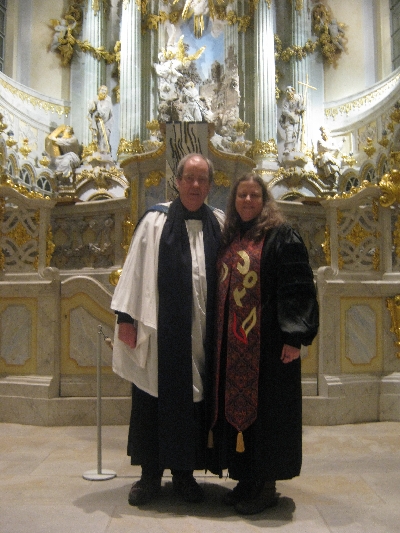
I have to say that I felt a lot less nervous leading the service last Sunday evening, than I did on my first outing last September. I really felt I had begun to build a bit of a rapport with some of the regular attendees. It was also a pleasure to hear Karen preach as she spoke about ‘The Foolishness of the Cross’, based on the Biblical text from 1 Corinthians 1. 18-31. We posed for this picture, under the pulpit, following the end of the service.
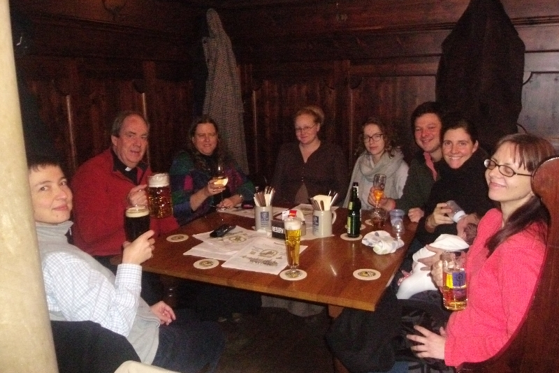
After getting dis-robed, Karen and I accepted an invitation to join a few of the congregation for a drink in a nearby Bierstube, the Augustiner an der FrauenkircheI ordered ein großes Bier, assuming I would get a 0.5l glass, in contrast to ein kleines Bier, a 0.3l glass. Much to everyone’s amusement, what arrived was ein sehr großes Bier, a one litre glass 😀 Evidence in this photograph.
After staying overnight in Hotel Martha, I had hoped to get some photographs of snowy Dresden in daylight, especially as the sky cleared and the sun came out as we were finishing our breakfast. But catching the correct trams to get back to Dresden Hbf in time for our train back to Prague, took greater priority. However, we were treated to some spectacular views on our train journey home, which I was able to capture.
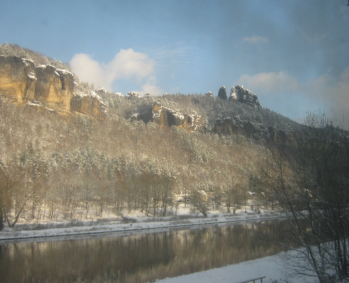
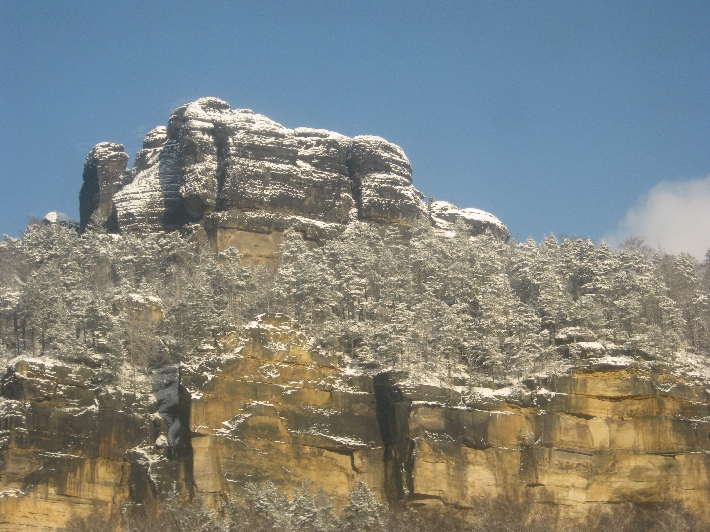
Soon after leaving Dresden, the railway line follows the valley of the River Elbe as it cuts through an area of sandstone mountains known as the Sächsische Schweiz – Saxon Switzerland. The mountains form the natural border between Germany and the Czech Republic. On the Czech side, the mountains are known as the Ceské Švýcarsko – Czech or Bohemian Switzerland. The name for the area was created by two Swiss artists, appointed to the Dresden Academy of Art in the second half of the eighteenth century. They believed the area to be very similar to their homeland in the Jura region of Switzerland.
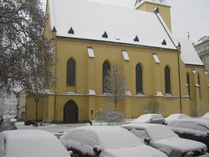
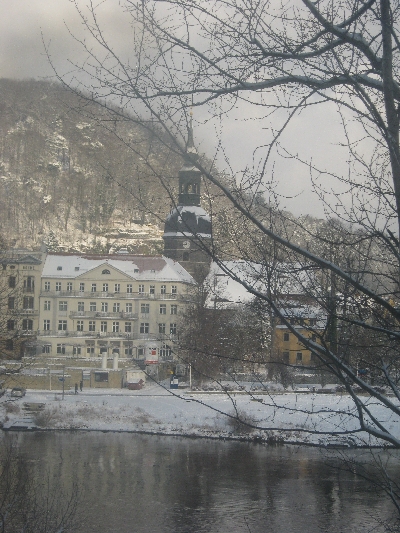
Just after passing through the spa town of Bad Schandau, the train came to an unscheduled halt, which allowed me to get this photograph of the Lutheran Parish Church of St John, Bad Schandau.
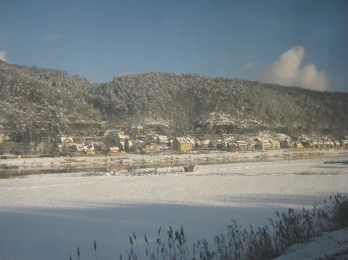
When we did continue, once a long freight train had passed by in the other direction, we moved very slowly onto the other track, to pass a broken down freight train blocking our track. This is what enabled me to take the following three photographs. Whilst this caused us to be fifteen minutes late getting back to Prague, on this occasion, I wasn’t complaining 🙂
Seeing this area, covered with snow and glistening in sun, has made me add Sächsische Schweiz andCeské Švýcarsko to my ever-lengthening bucket list of places I would like to visit and explore.